Difference between revisions of "2012-02-26 47 7"
imported>TheOneRing (→The Plan) |
imported>TheOneRing |
||
| Line 6: | Line 6: | ||
== Location == | == Location == | ||
| − | The geohash is not far from Berne. | + | The geohash is inside a forest not far from Berne. |
== Who Went == | == Who Went == | ||
| − | [[User:TheOneRing|TheOneRing]] - by bike. | + | [[User:TheOneRing|TheOneRing]] - by <s>bike</s> public transport. |
| − | == The | + | == The Expedition == |
=== TheOneRing === | === TheOneRing === | ||
| − | Is weather | + | Is weather was forecasted to be good, the spring is coming; perfect conditions to go on a bike tour. The geohash was located approximately 12km North of Berne in a forest next to an autobahn. |
| − | I | + | So far the plan, but one tire was flat. So, I took a train and walked through the forest. I didn't print a map so I had to rely on my GPS, which was fun because I didn't walk on the trails but cross-country. |
| + | |||
| + | The way through the forest from between snow-covered to green and muddy. Near the geohash the path got really icy, muddy and wet, so it was a final challenge ;) After reaching the geohash I made a short rest and took the usual photographs. It lied on a hillsides and On the way back I took a different route and finally another train to Berne. | ||
| + | |||
| + | == Photos == | ||
| + | === TheOneRing === | ||
| + | <gallery perrow="5"> | ||
| + | Image:20120226GPS.jpg|Exactly here... | ||
| + | Image:20120226Geohash.jpg|...in a muddy field was the geohash | ||
| + | Image:20120226Info.jpg|Some additional information | ||
| + | Image:20120226Me.jpg|A happy hasher | ||
| + | Image:20120226Surrounding.jpg|The hillside where the geohash was | ||
| + | </gallery> | ||
== Achievements == | == Achievements == | ||
| − | + | {{land geohash | latitude = 47 | longitude = 7 | date = 2012-02-26 | name = TheOneRing}} | |
| + | {{Public transport geohash | latitude = 47 | longitude = 7 | date = 2012-02-26 | name = TheOneRing }} | ||
Revision as of 17:20, 26 February 2012
| Sun 26 Feb 2012 in 47,7: 47.0000466, 7.4837187 geohashing.info google osm bing/os kml crox |
Contents
Location
The geohash is inside a forest not far from Berne.
Who Went
TheOneRing - by bike public transport.
The Expedition
TheOneRing
Is weather was forecasted to be good, the spring is coming; perfect conditions to go on a bike tour. The geohash was located approximately 12km North of Berne in a forest next to an autobahn.
So far the plan, but one tire was flat. So, I took a train and walked through the forest. I didn't print a map so I had to rely on my GPS, which was fun because I didn't walk on the trails but cross-country.
The way through the forest from between snow-covered to green and muddy. Near the geohash the path got really icy, muddy and wet, so it was a final challenge ;) After reaching the geohash I made a short rest and took the usual photographs. It lied on a hillsides and On the way back I took a different route and finally another train to Berne.
Photos
TheOneRing
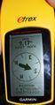
Exactly here...
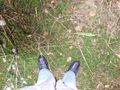
...in a muddy field was the geohash
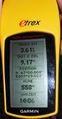
Some additional information

A happy hasher
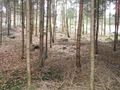
The hillside where the geohash was


Achievements
TheOneRing earned the Land geohash achievement
|
TheOneRing earned the Public transport geohash achievement
|