Difference between revisions of "2012-02-29 41 -73"
From Geohashing
imported>NCommander ([live picture] Hash point from the road. Approx 5 to 10 feet [http://www.openstreetmap.org/?lat=41.31285503&lon=-73.17933435&zoom=16&layers=B000FTF @41.3129,-73.1793]) |
imported>NCommander ([live picture] ground zero [http://www.openstreetmap.org/?lat=41.31290976&lon=-73.17942873&zoom=16&layers=B000FTF @41.3129,-73.1794]) |
||
| Line 43: | Line 43: | ||
Image:2012-02-29_41_-73_17-49-37-145.jpg | Hash point from the road. Approx 5 to 10 feet [http://www.openstreetmap.org/?lat=41.31285503&lon=-73.17933435&zoom=16&layers=B000FTF @41.3129,-73.1793] | Image:2012-02-29_41_-73_17-49-37-145.jpg | Hash point from the road. Approx 5 to 10 feet [http://www.openstreetmap.org/?lat=41.31285503&lon=-73.17933435&zoom=16&layers=B000FTF @41.3129,-73.1793] | ||
| + | |||
| + | Image:2012-02-29_41_-73_17-51-53-063.jpg | ground zero [http://www.openstreetmap.org/?lat=41.31290976&lon=-73.17942873&zoom=16&layers=B000FTF @41.3129,-73.1794] | ||
</gallery> | </gallery> | ||
Revision as of 22:51, 29 February 2012
| Wed 29 Feb 2012 in 41,-73: 41.3129303, -73.1794689 geohashing.info google osm bing/os kml crox |
Location
Participants
Plans
Expedition
- at the hash point or very close -- NCommander @41.3129,-73.1794 17:47, 29 February 2012 (EST)
Tracklog
Photos
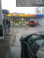
fueling @40.9181,-73.7751
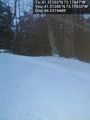
Hash point from the road. Approx 5 to 10 feet @41.3129,-73.1793
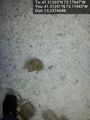
ground zero @41.3129,-73.1794


Achievements