Difference between revisions of "2012-03-18 -37 145"
From Geohashing
imported>MykaDragonBlue ([live picture] Arrived at Norton park. The hash is down that way [http://www.openstreetmap.org/?lat=-37.87920495&lon=145.19881320&zoom=16&layers=B000FTF @-37.8792,145.1988]) |
imported>MykaDragonBlue ([live picture] Retreating kozz' the hash photo [http://www.openstreetmap.org/?lat=-37.88200000&lon=145.19300000&zoom=16&layers=B000FTF @-37.8820,145.1930]) |
||
| Line 51: | Line 51: | ||
Image:2012-03-18_-37_145_12-51-31-173.jpg | Arrived at Norton park. The hash is down that way [http://www.openstreetmap.org/?lat=-37.87920495&lon=145.19881320&zoom=16&layers=B000FTF @-37.8792,145.1988] | Image:2012-03-18_-37_145_12-51-31-173.jpg | Arrived at Norton park. The hash is down that way [http://www.openstreetmap.org/?lat=-37.87920495&lon=145.19881320&zoom=16&layers=B000FTF @-37.8792,145.1988] | ||
| + | |||
| + | Image:2012-03-18_-37_145_13-19-41-030.jpg | Retreating kozz' the hash photo [http://www.openstreetmap.org/?lat=-37.88200000&lon=145.19300000&zoom=16&layers=B000FTF @-37.8820,145.1930] | ||
</gallery> | </gallery> | ||
Revision as of 02:19, 18 March 2012
| Sun 18 Mar 2012 in -37,145: -37.8819343, 145.1932346 geohashing.info google osm bing/os kml crox |
Location
Participants
- Kozz
- myka
- ez
Plans
Myka and Ez will be heading out after lunch, to have a look around
Expedition
- On my way out to the park now. Kozz 18:53, 17 March 2012 (EDT) -- Kozz 09:53, 18 March 2012 (GMT+11:00)
Tracklog
Photos
Reached!
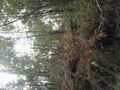
Hashpoint location
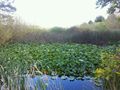
Ponds nearby
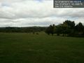
Arrived at Norton park. The hash is down that way @-37.8792,145.1988
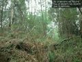
Retreating kozz' the hash photo @-37.8820,145.1930


Achievements