Difference between revisions of "2012-03-21 34 -83"
From Geohashing
imported>Junx (Created page with "{{subst:Expedition |lat = 34 |lon = -83 |date = 2012-03-21 }}") |
imported>Junx (→Photos) |
||
| Line 37: | Line 37: | ||
--> | --> | ||
<gallery perrow="5"> | <gallery perrow="5"> | ||
| + | Image:2012-03-21_34_-83_a.jpg | This is my bike, The Baron, parked where I ran out of road and had to continue on foot. | ||
| + | Image:2012-03-21_34_-83_b.jpg | I did not do any of the things on this sign. | ||
| + | Image:2012-03-21_34_-83_c.jpg | The closest my GPS got was 8 feet away, as is evidenced here. GPS has a 20-foot uncertainty radius, so I trampled around the woods for a while to make sure that wherever the point was, I was at it. | ||
| + | Image:2012-03-21_34_-83_d.jpg | I met this sweet ride on the way back through the woods. | ||
</gallery> | </gallery> | ||
Revision as of 03:46, 22 March 2012
| Wed 21 Mar 2012 in 34,-83: 34.3526419, -83.6082431 geohashing.info google osm bing/os kml crox |
Location
Participants
Plans
Expedition
Tracklog
Photos
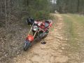
This is my bike, The Baron, parked where I ran out of road and had to continue on foot.
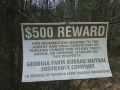
I did not do any of the things on this sign.
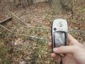
The closest my GPS got was 8 feet away, as is evidenced here. GPS has a 20-foot uncertainty radius, so I trampled around the woods for a while to make sure that wherever the point was, I was at it.
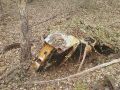
I met this sweet ride on the way back through the woods.


Achievements