Difference between revisions of "2012-04-25 52 5"
imported>Antior (Adding pictures, achievements and expanding report) |
imported>CO2 (Changing stuff to new username) |
||
| Line 11: | Line 11: | ||
== Participants == | == Participants == | ||
| − | * [[User: | + | * [[User:CO2|CO2]] |
* [[User:Tchakkazulu|Tchakkazulu]] | * [[User:Tchakkazulu|Tchakkazulu]] | ||
<!-- who attended: If you link to your wiki user name in this section, your expedition will be picked up by the various statistics generated for geohashing. You may use three tildes ~ as a shortcut to automatically insert the user signature of the account you are editing with. | <!-- who attended: If you link to your wiki user name in this section, your expedition will be picked up by the various statistics generated for geohashing. You may use three tildes ~ as a shortcut to automatically insert the user signature of the account you are editing with. | ||
| Line 17: | Line 17: | ||
== Plans == | == Plans == | ||
| − | [[User: | + | [[User:CO2|CO2]] will go by bike if and only if someone comes along with a GPS. That makes a forest hash like this MUCH easier to find. Please let me know if you want to go! |
[[User:Tchakkazulu|Tchakkazulu]] is interested. He has a GPS, but no bike, so he'll take a train to Den Dolder and walk from there. | [[User:Tchakkazulu|Tchakkazulu]] is interested. He has a GPS, but no bike, so he'll take a train to Den Dolder and walk from there. | ||
| Line 24: | Line 24: | ||
== Expedition == | == Expedition == | ||
| − | Tchakkazulu managed to miss yet another train, so he arrived at 13:17. | + | Tchakkazulu managed to miss yet another train, so he arrived at 13:17. CO2 was already there, and together they walked in the general direction of the hash. When being 300 meters away from the hash, CO2's suspicion proved correct: gates closed. The area isn't publicly accessible, but belongs to some estate further up north. |
We took some pictures, and followed the path further on. The nearest we got was 180 meters. We went around the lands, but gates everywhere were as closed as they get. | We took some pictures, and followed the path further on. The nearest we got was 180 meters. We went around the lands, but gates everywhere were as closed as they get. | ||
| − | + | CO2 arrived at the station by bike. We were really not sure if we were going to reach this one, google maps wasn't clear, nor was the website we found about the estate property (Ewijckshoeve). At least it was a nice forest walk. The little bit of rain couldn't stop us. As you can see in the last picture, we met some real gnomes. | |
| Line 47: | Line 47: | ||
| longitude = 5 | | longitude = 5 | ||
| date = 2012-04-25 | | date = 2012-04-25 | ||
| − | | name = | + | | name = CO2 and Tchakkazulu |
| image = 25-4-2012_52_5a.jpg | | image = 25-4-2012_52_5a.jpg | ||
Revision as of 20:22, 7 March 2014
| Wed 25 Apr 2012 in 52,5: 52.1620361, 5.2516992 geohashing.info google osm bing/os kml crox |
Location
Landgoed Ewijckshoeve near Lage Vuursche. Middle of the forest. Not sure if wanderers are allowed in that area.
Participants
Plans
CO2 will go by bike if and only if someone comes along with a GPS. That makes a forest hash like this MUCH easier to find. Please let me know if you want to go!
Tchakkazulu is interested. He has a GPS, but no bike, so he'll take a train to Den Dolder and walk from there.
It's about 30-40 minutes walking from the station to #. We'll try to meet at about 13:00 at the station. Tchakkazulu will take the train that arrives at 12:47, and failing that, the next one that arrives at 13:04.
Expedition
Tchakkazulu managed to miss yet another train, so he arrived at 13:17. CO2 was already there, and together they walked in the general direction of the hash. When being 300 meters away from the hash, CO2's suspicion proved correct: gates closed. The area isn't publicly accessible, but belongs to some estate further up north.
We took some pictures, and followed the path further on. The nearest we got was 180 meters. We went around the lands, but gates everywhere were as closed as they get.
CO2 arrived at the station by bike. We were really not sure if we were going to reach this one, google maps wasn't clear, nor was the website we found about the estate property (Ewijckshoeve). At least it was a nice forest walk. The little bit of rain couldn't stop us. As you can see in the last picture, we met some real gnomes.
Photos
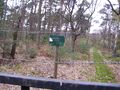
"No trespassing"
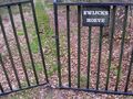
The 'closed' gate next to the no trespassing sign.
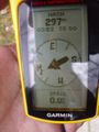
GPS reading next to gate.
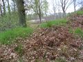
The hash was possibly somewhere on that field. Picture taken at the fence.
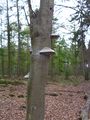
A tree near our path. Gnomes live in it.


Achievements
CO2 and Tchakkazulu earned the No trespassing consolation prize
|