Difference between revisions of "2012-05-09 54 23"
imported>Vinska (New page for an expedition.) |
imported>Jiml m (Add result code) |
||
| Line 7: | Line 7: | ||
}} | }} | ||
| − | + | ||
__NOTOC__ | __NOTOC__ | ||
== Location == | == Location == | ||
| − | + | ||
In Kaunas, near a gas station. | In Kaunas, near a gas station. | ||
== Participants == | == Participants == | ||
| − | + | ||
| − | |||
*[[User:Vinska|Vinska]] | *[[User:Vinska|Vinska]] | ||
== Plans == | == Plans == | ||
| − | |||
It was quite spontaneous. | It was quite spontaneous. | ||
== Expedition == | == Expedition == | ||
| − | |||
| − | Living in an inactive graticule for this long - this had to be 'fixed'. Checked the today's location on an online map - "heck, this is quite close, I have to do this today!". I do not expect anyone else to go on geohashing here. So I assume I am the only one. I suppose, not a good thing to do, to assume that, though. | + | |
| − | Took a backpack with two bottles of water, some cookies, and also, one special item; Put on my trusty boots; And went away! On foot. Decided it would be fun to run the whole distance, so I did just that. Except when I stopped to take photos and or/have a drink. Finally I was almost at the geohashing location, but noticed it was on a restricted area. "Bummer..." - I thought to myself, and went to look for a place nearby, to rest my legs. I sat down on the grass, by a bush, took a drink, and rested a little. After catching my breath, I manned up, went there anyway and took a photo. Nobody seemed to have noticed and/or cared. I returned to the place I sat previously. Ate my cookies and finished my remaining water. Then, I took out the "Special Item". It was a book - 'The C Programming Language'. I could say - 'obligatory nerdiness'. After ten minutes of reading, I took note on early warnings of my bladder, and decided to set out. Unlike I did when going to the place - ran, I walked when going back. Due to some findings of that run, I altered the course a little. I safely reached my home in the end. Started the expedition on 12:03 EEST / 09:03 UTC; Reached the destination on 12:50 EEST / 09:50 UTC; Came back home at 14:25 EEST / 11:25 UTC; | + | Living in an inactive graticule for this long - this had to be 'fixed'. Checked the |
| + | today's location on an online map - "heck, this is quite close, I have to do this | ||
| + | today!". I do not expect anyone else to go on geohashing here. So I assume I am | ||
| + | the only one. I suppose, not a good thing to do, to assume that, though. | ||
| + | |||
| + | Took a backpack with two bottles of water, some cookies, and also, one special item; | ||
| + | Put on my trusty boots; And went away! On foot. | ||
| + | |||
| + | Decided it would be fun to run the | ||
| + | whole distance, so I did just that. Except when I stopped to take photos and or/have | ||
| + | a drink. Finally I was almost at the geohashing location, but noticed it was on a | ||
| + | restricted area. "Bummer..." - I thought to myself, and went to look for a place | ||
| + | nearby, to rest my legs. | ||
| + | |||
| + | I sat down on the grass, by a bush, took a drink, and | ||
| + | rested a little. After catching my breath, I manned up, went there anyway and | ||
| + | took a photo. Nobody seemed to have noticed and/or cared. | ||
| + | |||
| + | I returned to the | ||
| + | place I sat previously. Ate my cookies and finished my remaining water. Then, I | ||
| + | took out the "Special Item". It was a book - 'The C Programming Language'. I could | ||
| + | say - 'obligatory nerdiness'. After ten minutes of reading, I took note on early | ||
| + | warnings of my bladder, and decided to set out. Unlike I did when going to the | ||
| + | place - ran, I walked when going back. Due to some findings of that run, I | ||
| + | altered the course a little. I safely reached my home in the end. | ||
| + | |||
| + | Started the expedition on 12:03 EEST / 09:03 UTC; Reached the destination on 12:50 EEST / 09:50 UTC; Came back home at 14:25 EEST / 11:25 UTC; | ||
== The Failure == | == The Failure == | ||
| − | Now, I should note: I do not own a stand-alone GPS device, and the GPS in my cellphone is a complete mess - refuses to work when it has no access to the internet. Internet connection on my phone is quite expensive. Thus, I keep it off at all times. And even when it can connect, it never managed to work before in the first place - always kept on searching for the satellites, and failing. So, I had to rely on my memory, and try to remember the exact location. | + | Now, I should note: I do not own a stand-alone GPS device, and the GPS in my cellphone |
| + | is a complete mess - refuses to work when it has no access to the internet. Internet | ||
| + | connection on my phone is quite expensive. Thus, I keep it off at all times. And even | ||
| + | when it can connect, it never managed to work before in the first place - always kept | ||
| + | on searching for the satellites, and failing. So, I had to rely on my memory, and try to remember the exact location. | ||
| + | |||
When I sat down to document my expedition, I checked the map again. Then, I realized - "CURSES!!! I went to the wrong spot! I remembered it incorrectly and went to a wrong point which was 100 meters away from the right one! NOOOOOOO!!!!" | When I sat down to document my expedition, I checked the map again. Then, I realized - "CURSES!!! I went to the wrong spot! I remembered it incorrectly and went to a wrong point which was 100 meters away from the right one! NOOOOOOO!!!!" | ||
| + | |||
The closest I was to the 'right' point was ~30 meters away. I assume that does not count as 'reaching'. The location I reached was [http://maps.google.com/maps?q=loc:54.93016,+23.9744 this (google maps)], the closest I was to the 'right' location [http://maps.google.com/maps?q=loc:54.92917,+23.97338 was here (google maps)]. Oh well, maybe next time... | The closest I was to the 'right' point was ~30 meters away. I assume that does not count as 'reaching'. The location I reached was [http://maps.google.com/maps?q=loc:54.93016,+23.9744 this (google maps)], the closest I was to the 'right' location [http://maps.google.com/maps?q=loc:54.92917,+23.97338 was here (google maps)]. Oh well, maybe next time... | ||
| − | + | ||
| − | |||
== Photos == | == Photos == | ||
| − | + | ||
| − | |||
| − | |||
<gallery perrow="5"> | <gallery perrow="5"> | ||
Image:2012-05-09_54_23-start.jpg | Start of the expedition. [http://maps.google.com/maps?q=loc:54.90482,+23.96383 here (google maps)] | Image:2012-05-09_54_23-start.jpg | Start of the expedition. [http://maps.google.com/maps?q=loc:54.90482,+23.96383 here (google maps)] | ||
| Line 54: | Line 80: | ||
</gallery> | </gallery> | ||
| − | |||
| − | |||
| − | |||
| Line 62: | Line 85: | ||
[[Category:Expeditions with photos]] | [[Category:Expeditions with photos]] | ||
[[Category:Coordinates not reached]] | [[Category:Coordinates not reached]] | ||
| + | [[Category:Not reached - Technology]] | ||
Revision as of 00:10, 10 May 2012
| Wed 9 May 2012 in Kaunas: 54.9293238, 23.9731768 geohashing.info google osm bing/os kml crox |
Location
In Kaunas, near a gas station.
Participants
Plans
It was quite spontaneous.
Expedition
Living in an inactive graticule for this long - this had to be 'fixed'. Checked the today's location on an online map - "heck, this is quite close, I have to do this today!". I do not expect anyone else to go on geohashing here. So I assume I am the only one. I suppose, not a good thing to do, to assume that, though.
Took a backpack with two bottles of water, some cookies, and also, one special item; Put on my trusty boots; And went away! On foot.
Decided it would be fun to run the whole distance, so I did just that. Except when I stopped to take photos and or/have a drink. Finally I was almost at the geohashing location, but noticed it was on a restricted area. "Bummer..." - I thought to myself, and went to look for a place nearby, to rest my legs.
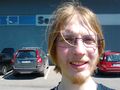
I sat down on the grass, by a bush, took a drink, and rested a little. After catching my breath, I manned up, went there anyway and took a photo. Nobody seemed to have noticed and/or cared.
I returned to the place I sat previously. Ate my cookies and finished my remaining water. Then, I took out the "Special Item". It was a book - 'The C Programming Language'. I could say - 'obligatory nerdiness'. After ten minutes of reading, I took note on early warnings of my bladder, and decided to set out. Unlike I did when going to the place - ran, I walked when going back. Due to some findings of that run, I altered the course a little. I safely reached my home in the end.
Started the expedition on 12:03 EEST / 09:03 UTC; Reached the destination on 12:50 EEST / 09:50 UTC; Came back home at 14:25 EEST / 11:25 UTC;
The Failure
Now, I should note: I do not own a stand-alone GPS device, and the GPS in my cellphone is a complete mess - refuses to work when it has no access to the internet. Internet connection on my phone is quite expensive. Thus, I keep it off at all times. And even when it can connect, it never managed to work before in the first place - always kept on searching for the satellites, and failing. So, I had to rely on my memory, and try to remember the exact location.
When I sat down to document my expedition, I checked the map again. Then, I realized - "CURSES!!! I went to the wrong spot! I remembered it incorrectly and went to a wrong point which was 100 meters away from the right one! NOOOOOOO!!!!"
The closest I was to the 'right' point was ~30 meters away. I assume that does not count as 'reaching'. The location I reached was this (google maps), the closest I was to the 'right' location was here (google maps). Oh well, maybe next time...
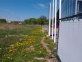
Photos
Start of the expedition. here (google maps)

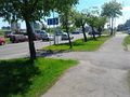
A "checkpoint" - ran past my old school on the way. here (google maps)
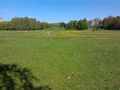
...and later, through a park. here (google maps)
Can't cross the road here without breaking the law. Going around... here (google maps)
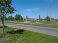
~500 meters away, a crosswalk. Law Breaking averted! here (google maps)
Uh oh! Restricted area!
Manned up and reached the (wrong) location here (google maps)
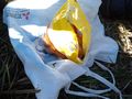
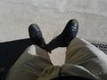
Ate some cookies!
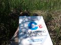
..."Nerd out by read a book!" Obligatory nerdiness, weee!


