Difference between revisions of "2012-04-28 55 13"
From Geohashing
imported>Fasanen (Created page with "{{subst:Expedition |lat = 55 |lon = 13 |date = 2012-04-28 }}") |
imported>Fasanen (Second hashiversery expedition) |
||
| Line 1: | Line 1: | ||
| − | |||
| − | |||
| − | |||
| − | |||
| − | |||
{{meetup graticule | {{meetup graticule | ||
| lat=55 | | lat=55 | ||
| Line 10: | Line 5: | ||
}} | }} | ||
| − | |||
__NOTOC__ | __NOTOC__ | ||
== Location == | == Location == | ||
| − | + | In a field outside Alstad, Skåne, Sweden. | |
== Participants == | == Participants == | ||
| − | + | Fasanen | |
| − | |||
== Plans == | == Plans == | ||
| − | + | Celebrate second hashiversary. | |
== Expedition == | == Expedition == | ||
| − | + | Fasanen knew this place was not going to be accessible. He passed it on way home from work already the day before and could establish the fact | |
| − | + | that the approach to the geohash would be over cultivated land. However this day was his second hashiversary and he passed the geohash again and | |
| − | + | quietly celebrated by taking a photograph of the unreachable and boring coordinates from a distance of 75 meters. | |
| − | |||
== Photos == | == Photos == | ||
| − | < | + | <gallery perrow="4"> |
| − | Image: | + | Image:201204285513 01.jpg| About 20 meters to the left of the trees... |
| − | + | Image:201204285513 02.jpg| Road 101 (looking east) which according to some, divide Sweden in two halves :-) | |
| − | |||
</gallery> | </gallery> | ||
== Achievements == | == Achievements == | ||
{{#vardefine:ribbonwidth|800px}} | {{#vardefine:ribbonwidth|800px}} | ||
| − | + | {{No trespassing | |
| + | | latitude = 55 | ||
| + | | longitude = 13 | ||
| + | | date = 2012-04-28 | ||
| + | | name = [[User:Fasanen|Fasanen]] | ||
| + | }} | ||
| + | {{hashiversary|name=Fasanen|new=2012-04-28 55 13|original=2010-04-28|gender=his}} | ||
| − | |||
| − | |||
| − | |||
| − | |||
| − | |||
| − | |||
| − | |||
| − | |||
| − | |||
[[Category:Expeditions]] | [[Category:Expeditions]] | ||
| − | |||
[[Category:Expeditions with photos]] | [[Category:Expeditions with photos]] | ||
| − | |||
| − | |||
| − | |||
| − | |||
| − | |||
| − | |||
| − | |||
| − | |||
| − | |||
[[Category:Coordinates not reached]] | [[Category:Coordinates not reached]] | ||
| − | + | [[Category:Not reached - No public access]] | |
| − | |||
| − | [[Category:Not reached - No public access]] | ||
| − | |||
| − | |||
| − | |||
Revision as of 14:41, 12 May 2012
| Sat 28 Apr 2012 in 55,13: 55.4519755, 13.2477861 geohashing.info google osm bing/os kml crox |
Location
In a field outside Alstad, Skåne, Sweden.
Participants
Fasanen
Plans
Celebrate second hashiversary.
Expedition
Fasanen knew this place was not going to be accessible. He passed it on way home from work already the day before and could establish the fact that the approach to the geohash would be over cultivated land. However this day was his second hashiversary and he passed the geohash again and quietly celebrated by taking a photograph of the unreachable and boring coordinates from a distance of 75 meters.
Photos
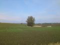
About 20 meters to the left of the trees...
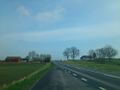
Road 101 (looking east) which according to some, divide Sweden in two halves :-)


Achievements
Fasanen earned the No trespassing consolation prize
|
Fasanen earned the Hashiversary achievement
|