Difference between revisions of "2012-05-12 40 -105"
imported>Squenes |
imported>Squenes |
||
| Line 15: | Line 15: | ||
== Expedition == | == Expedition == | ||
| − | Sadly, I was foiled by a locked gate with a no trespassing sign on it. Mind you, I had considered the possibility of encountering private property and had formulated a bit of a plan to get around it, but this no trespassing zone was well before I ever got to the area I had been concerned about, so I was unable to proceed. The closest I got to the hash point was about 1.75 km/1.09 mi away, so I'll have to settle for a no trespassing ribbon. | + | Sadly, I was foiled by a locked gate with a no trespassing sign on it. In fact, the sign not only forbade trespassing, but warned that violators would be prosecuted, and since I had no desire to be prosecuted, I turned back at that point. Mind you, I had considered the possibility of encountering private property and had formulated a bit of a plan to get around it, but this no trespassing zone was well before I ever got to the area that I had been concerned about, so I was unable to proceed. The closest I got to the hash point was about 1.75 km/1.09 mi away, so I'll have to settle for a no trespassing ribbon. More details to come soon... |
== Photos == | == Photos == | ||
| − | |||
| − | |||
| − | |||
<gallery perrow="5"> | <gallery perrow="5"> | ||
| + | Image:2012-05-12_40_-105_gate.JPG|Uh oh, this doesn't look good... | ||
| + | Image:2012-05-12_40_-105_sign.JPG|Drat, my expedition ends here | ||
| + | Image:2012-05-12_40_-105_gps.JPG|As close as I got to the hash point, about 1.75 km away | ||
| + | Image:2012-05-12_40_-105_cattle.JPG|Cattle grazing on the private property that halted my progress | ||
| + | Image:2012-05-12_40_-105_highway.JPG|A view of US 287 winding northward | ||
| + | Image:2012-05-12_40_-105_road.JPG|The inaccessible dirt road leading toward the hash point | ||
| + | Image:2012-05-12_40_-105_pout.JPG|My Cheesy Exaggerated Pout™ next to the no trespassing sign | ||
| + | Image:2012-05-12_40_-105_stupidGrin.JPG|My Stupid Grin™, since I still enjoyed the trip | ||
</gallery> | </gallery> | ||
== Achievements == | == Achievements == | ||
| − | + | {{No trespassing | latitude = 40 | longitude = -105 | date = 2012-05-12 | image = 2012-05-12_40_-105_pout.JPG | name= [[User:Squenes|Squenes]]}} | |
[[Category:Expeditions]] | [[Category:Expeditions]] | ||
| − | |||
[[Category:Expeditions with photos]] | [[Category:Expeditions with photos]] | ||
| − | |||
[[Category:Coordinates not reached]] | [[Category:Coordinates not reached]] | ||
[[Category:Not reached - No public access]] | [[Category:Not reached - No public access]] | ||
Revision as of 05:06, 14 May 2012
| Sat 12 May 2012 in 40,-105: 40.9260412, -105.3618228 geohashing.info google osm bing/os kml crox |
Location
Part of the way up some bluffs by a creek, about 2 miles south-southwest of Virginia Dale, CO
Participants
Plans
According to the county parcel locator, the hash point is on "state school land," and my paper atlas shows the area as public state land, so in theory, the point should be accessible. However, it looks like the dirt track that heads toward the point crosses some private property, so it may take a little creative maneuvering to get there. I'm planning to head to the spot later this afternoon, aiming to drive as close to the point as I can (without passing any no trespassing signs) and walking the rest of the way from there. It's also hard to tell exactly how substantial this creek is from the aerial images, so that may pose another obstacle. I have some shopping to do, so I might not make it by 4:00 PM, but I'll try to get there in the 4:00-6:00 PM time frame at least.
Expedition
Sadly, I was foiled by a locked gate with a no trespassing sign on it. In fact, the sign not only forbade trespassing, but warned that violators would be prosecuted, and since I had no desire to be prosecuted, I turned back at that point. Mind you, I had considered the possibility of encountering private property and had formulated a bit of a plan to get around it, but this no trespassing zone was well before I ever got to the area that I had been concerned about, so I was unable to proceed. The closest I got to the hash point was about 1.75 km/1.09 mi away, so I'll have to settle for a no trespassing ribbon. More details to come soon...
Photos
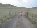
Uh oh, this doesn't look good...
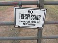
Drat, my expedition ends here
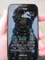
As close as I got to the hash point, about 1.75 km away
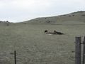
Cattle grazing on the private property that halted my progress
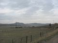
A view of US 287 winding northward
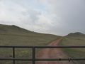
The inaccessible dirt road leading toward the hash point
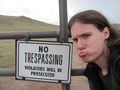
My Cheesy Exaggerated Pout™ next to the no trespassing sign

My Stupid Grin™, since I still enjoyed the trip


Achievements
Squenes earned the No trespassing consolation prize
|