Difference between revisions of "2012-06-23 50 10"
From Geohashing
imported>Reinhard m (→Expedition) |
imported>Reinhard m (→Photos) |
||
| Line 17: | Line 17: | ||
== Photos == | == Photos == | ||
| − | {{gallery|width=200|height=200|lines= | + | {{gallery|width=200|height=200|lines=1 |
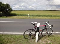
|Image:20120623-50N10E-01.jpg|View towards hashpoint. | |Image:20120623-50N10E-01.jpg|View towards hashpoint. | ||
|Image:20120623-50N10E-02.jpg|118 m to go. | |Image:20120623-50N10E-02.jpg|118 m to go. | ||
Revision as of 18:09, 24 June 2012
| Sat 23 Jun 2012 in 50,10: 50.4188367, 10.7861832 geohashing.info google osm bing/os kml crox |
Location
On a field near Heßberg / Hildburghausen.
Participants
Expedition
An other weekend in Schleusingerneundorf and warm weather - I just had to cycle somewhere and the hash was close enough for a two- or three-hour ride. I knew that it would be on a field and chances weren't too big I could step on it. In deed, I found the hash field with rye or barley in full bloom and didn't see any tractor tracks leading me to the hashpoint which was more than 100 m from the road. Thus, I just took the photos of failure and rode on without being disappointed.
Photos
|


