Difference between revisions of "2012-06-27 33 -117"
From Geohashing
imported>LucasBrown ([live picture] The hashpoint: 35m ahead, in brush too dense to penetrate. The Deer Park Monastery is in the distance. [http://www.openstreetmap.org/?lat=33.18675755&lon=-117.07702637&zoom=16&layers=B000FTF @33.1868,-117.0770]) |
imported>LucasBrown ([live picture] Geohash Droid map, 35m out [http://www.openstreetmap.org/?lat=33.18675685&lon=-117.07702391&zoom=16&layers=B000FTF @33.1868,-117.0770]) |
||
| Line 42: | Line 42: | ||
Image:2012-06-27_33_-117_17-24-03-979.jpg | The hashpoint: 35m ahead, in brush too dense to penetrate. The Deer Park Monastery is in the distance. [http://www.openstreetmap.org/?lat=33.18675755&lon=-117.07702637&zoom=16&layers=B000FTF @33.1868,-117.0770] | Image:2012-06-27_33_-117_17-24-03-979.jpg | The hashpoint: 35m ahead, in brush too dense to penetrate. The Deer Park Monastery is in the distance. [http://www.openstreetmap.org/?lat=33.18675755&lon=-117.07702637&zoom=16&layers=B000FTF @33.1868,-117.0770] | ||
| + | |||
| + | Image:2012-06-27_33_-117_17-24-58-488.jpg | Geohash Droid map, 35m out [http://www.openstreetmap.org/?lat=33.18675685&lon=-117.07702391&zoom=16&layers=B000FTF @33.1868,-117.0770] | ||
</gallery> | </gallery> | ||
Revision as of 00:25, 28 June 2012
| Wed 27 Jun 2012 in 33,-117: 33.1869405, -117.0767071 geohashing.info google osm bing/os kml crox |
Location
Participants
Plans
Expedition
Tracklog
Photos
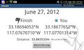
Geohash Droid details page, 35m out @33.1868,-117.0770
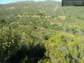
The hashpoint: 35m ahead, in brush too dense to penetrate. The Deer Park Monastery is in the distance. @33.1868,-117.0770
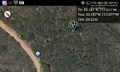
Geohash Droid map, 35m out @33.1868,-117.0770


Achievements