Difference between revisions of "2012-07-23 32 -116"
From Geohashing
imported>LucasBrown ([live picture] Benchmark on the trail [http://www.openstreetmap.org/?lat=32.92250000&lon=-116.97900000&zoom=16&layers=B000FTF @32.9225,-116.9790]) |
imported>Jiml m (Adjust result codes) |
||
| Line 1: | Line 1: | ||
| − | |||
<!-- If you did not specify these parameters in the template, please substitute appropriate values for IMAGE, LAT, LON, and DATE (YYYY-MM-DD format) | <!-- If you did not specify these parameters in the template, please substitute appropriate values for IMAGE, LAT, LON, and DATE (YYYY-MM-DD format) | ||
| Line 19: | Line 18: | ||
== Location == | == Location == | ||
<!-- where you've surveyed the hash to be --> | <!-- where you've surveyed the hash to be --> | ||
| + | |||
| + | Trailhead near Santee (?) | ||
== Participants == | == Participants == | ||
| Line 55: | Line 56: | ||
[[Category:New report]] | [[Category:New report]] | ||
| − | |||
| − | |||
| − | |||
| − | |||
| − | + | ||
| + | |||
[[Category:Expeditions]] | [[Category:Expeditions]] | ||
| − | |||
[[Category:Expeditions with photos]] | [[Category:Expeditions with photos]] | ||
| − | [[Category: | + | |
| − | [[Category: | + | [[Category:Coordinates not reached]] |
| − | + | [[Category:Not reached - No public access]] | |
| − | + | ||
| + | |||
| + | |||
| + | |||
<!-- if you reached your coords: | <!-- if you reached your coords: | ||
[[Category:Coordinates reached]] | [[Category:Coordinates reached]] | ||
Revision as of 20:10, 24 July 2012
| Mon 23 Jul 2012 in 32,-116: 32.9134977, -116.9782276 geohashing.info google osm bing/os kml crox |
Location
Trailhead near Santee (?)
Participants
Plans
Expedition
Tracklog
Photos
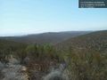
View from the trail near the trailhead @32.9286,-116.9720
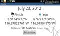
Closest approach (called off due to migraine) @32.9224,-116.9791
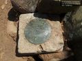
Benchmark on the trail @32.9225,-116.9790


Achievements