Difference between revisions of "2012-07-23 32 -116"
From Geohashing
imported>Jiml m (Adjust result codes) |
imported>Jiml m (Result codes look right) |
||
| Line 22: | Line 22: | ||
== Participants == | == Participants == | ||
| − | + | ||
| − | + | * [[User:LucasBrown]] | |
== Plans == | == Plans == | ||
| Line 35: | Line 35: | ||
== Photos == | == Photos == | ||
| − | + | ||
| − | |||
| − | |||
<gallery perrow="5"> | <gallery perrow="5"> | ||
Image:2012-07-23_32_-116_10-56-28-767.jpg | View from the trail near the trailhead [http://www.openstreetmap.org/?lat=32.92860000&lon=-116.97200000&zoom=16&layers=B000FTF @32.9286,-116.9720] | Image:2012-07-23_32_-116_10-56-28-767.jpg | View from the trail near the trailhead [http://www.openstreetmap.org/?lat=32.92860000&lon=-116.97200000&zoom=16&layers=B000FTF @32.9286,-116.9720] | ||
| − | |||
Image:2012-07-23_32_-116_11-20-49-982.jpg | Closest approach (called off due to migraine) [http://www.openstreetmap.org/?lat=32.92236606&lon=-116.97910807&zoom=16&layers=B000FTF @32.9224,-116.9791] | Image:2012-07-23_32_-116_11-20-49-982.jpg | Closest approach (called off due to migraine) [http://www.openstreetmap.org/?lat=32.92236606&lon=-116.97910807&zoom=16&layers=B000FTF @32.9224,-116.9791] | ||
| − | |||
Image:2012-07-23_32_-116_11-21-18-244.jpg | Benchmark on the trail [http://www.openstreetmap.org/?lat=32.92250000&lon=-116.97900000&zoom=16&layers=B000FTF @32.9225,-116.9790] | Image:2012-07-23_32_-116_11-21-18-244.jpg | Benchmark on the trail [http://www.openstreetmap.org/?lat=32.92250000&lon=-116.97900000&zoom=16&layers=B000FTF @32.9225,-116.9790] | ||
</gallery> | </gallery> | ||
| Line 51: | Line 47: | ||
<!-- Add any achievement ribbons you earned below, or remove this section --> | <!-- Add any achievement ribbons you earned below, or remove this section --> | ||
| − | + | * No trespassing | |
| − | |||
| − | |||
| − | |||
| − | |||
| − | |||
| − | |||
[[Category:Expeditions]] | [[Category:Expeditions]] | ||
| Line 64: | Line 54: | ||
[[Category:Coordinates not reached]] | [[Category:Coordinates not reached]] | ||
[[Category:Not reached - No public access]] | [[Category:Not reached - No public access]] | ||
| − | |||
| − | |||
| − | |||
| − | |||
| − | |||
| − | |||
| − | |||
| − | |||
| − | |||
| − | |||
| − | |||
| − | |||
| − | |||
| − | |||
| − | |||
| − | |||
| − | |||
| − | |||
| − | |||
| − | |||
| − | |||
| − | |||
| − | |||
| − | |||
Revision as of 03:40, 24 March 2013
| Mon 23 Jul 2012 in 32,-116: 32.9134977, -116.9782276 geohashing.info google osm bing/os kml crox |
Location
Trailhead near Santee (?)
Participants
Plans
Expedition
Tracklog
Photos
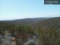
View from the trail near the trailhead @32.9286,-116.9720
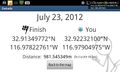
Closest approach (called off due to migraine) @32.9224,-116.9791
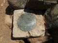
Benchmark on the trail @32.9225,-116.9790


Achievements
- No trespassing