Difference between revisions of "2012-08-10 32 -117"
From Geohashing
imported>LucasBrown ([live picture] Geohash Droid map at the hashpoint (LucasBrown) [http://www.openstreetmap.org/?lat=32.83472066&lon=-117.22353637&zoom=16&layers=B000FTF @32.8347,-117.2235]) |
imported>LucasBrown (→Participants) |
||
| Line 25: | Line 25: | ||
[[User:JesseW|JesseW]] 12:01, 10 August 2012 (EDT) <br> | [[User:JesseW|JesseW]] 12:01, 10 August 2012 (EDT) <br> | ||
[[User:Mathgeek|Todd (Mathgeek)]] 12:08, 10 August 2012 (EDT) | [[User:Mathgeek|Todd (Mathgeek)]] 12:08, 10 August 2012 (EDT) | ||
| + | [[User:LucasBrown|LucasBrown]] 18:40, 2012-08-10 | ||
== Plans == | == Plans == | ||
Revision as of 01:42, 11 August 2012
| Fri 10 Aug 2012 in 32,-117: 32.8347024, -117.2235842 geohashing.info google osm bing/os kml crox |
Location
In front of 2854 Luna Avenue, San Diego.
Participants
JesseW 12:01, 10 August 2012 (EDT)
Todd (Mathgeek) 12:08, 10 August 2012 (EDT)
LucasBrown 18:40, 2012-08-10
Plans
JesseW: It's a 10 minute drive from my house, how can I not go. I plan to drive over this morning, and be there by about 9:30 AM.
I should be able to swing by on the way home from work. -- Mathgeek 09:09, 10 August 2012 (PDT)
Expedition
- I am here.... Nice neighborhood. -- Mathgeek @32.8347,-117.2236 16:49, 10 August 2012 (PDT)
Tracklog
Photos

Geohash Droid details page at the hashpoint @32.8347,-117.2236
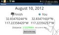
Geohash Droid details page at the hashpoint (LucasBrown) @32.8347,-117.2236
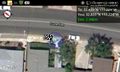
Geohash Droid map at the hashpoint (LucasBrown) @32.8347,-117.2235


Achievements