Difference between revisions of "2012-08-20 -35 149"
imported>1PE m (→Achievements) |
imported>1PE |
||
| Line 1: | Line 1: | ||
| − | + | [[Image:{{{image|2012-08-20 -35 149 attempt.JPG}}}|thumb|right]] | |
| − | |||
| − | [[Image:{{{image| | ||
| − | |||
| − | |||
| − | |||
| − | |||
| − | |||
| − | |||
{{meetup graticule | {{meetup graticule | ||
| lat=-35 | | lat=-35 | ||
| Line 20: | Line 12: | ||
== Participants == | == Participants == | ||
| − | + | [[User:1PE|1PE (Canberra)]] | |
| − | |||
== Plans == | == Plans == | ||
| Line 28: | Line 19: | ||
== Expedition == | == Expedition == | ||
| − | + | ===[[User:1PE|1PE]]=== | |
| + | I was thwarted by the golf course's fence and gate, and poor posture on the bike. and, the frost on the windscreen when I attempted to leave in plenty of time, so I wasted around 5-10 minutes warming the car/windscreen to clear the frost and so arrived at about 12:10am. | ||
| − | + | The country club is not open at night, oddly! The suburban cul-de-sacs do not give access to the course. | |
| − | + | ||
| + | After driving to a street adjacent to the hash (Tange Place), I attempted a ride-around at what I thought would be an access point near a bike-path overpass near the hash, but proved to have a fence, too. As I turned there, I lost balance and hit the tarmac pathway and scored cuts to both hands, left elbow, and left knee. | ||
| + | |||
| + | Undeterred, I got the 'proof', beside the fence, then rode back to the car. | ||
| + | |||
| + | On the way back, I got some pics at the locked gate of the country club. | ||
== Photos == | == Photos == | ||
| Line 38: | Line 35: | ||
--> | --> | ||
<gallery perrow="5"> | <gallery perrow="5"> | ||
| + | file:2012-08-20 -35 149 attempt.JPG|Thwarted by the golf course's fence and gate, and poor posture on the bike. | ||
| + | file:2012-08-20 -35 149 club.JPG|Gold Creek Country Club entrance at a bit after midnight. | ||
| + | |||
</gallery> | </gallery> | ||
| Line 43: | Line 43: | ||
{{#vardefine:ribbonwidth|800px}} | {{#vardefine:ribbonwidth|800px}} | ||
<!-- Add any achievement ribbons you earned below, or remove this section --> | <!-- Add any achievement ribbons you earned below, or remove this section --> | ||
| − | + | {{consecutive geohash | |
| − | + | | count = 2 Midnight & Frozen | |
| − | + | | latitude = -35 | |
| − | + | | longitude = 149 | |
| − | + | | date = 2012-08-19 | |
| − | + | | name = [[User:1PE|1PE (Canberra)]] | |
| + | }} | ||
| + | {{Midnight geohash | ||
| + | | latitude = -35 | ||
| + | | longitude = 149 | ||
| + | | date = 2012-08-20 | ||
| + | | name = [[User:1PE|1PE (Canberra)]] | ||
| + | | image = 2012-08-20 -35 149 attempt.JPG | ||
| + | }} | ||
| + | ''Consecutive'' | ||
| − | + | {{Frozen Geohash | |
| − | + | | latitude = -35 | |
| − | [[ | + | | longitude = 149 |
| + | | date = 2012-08-20 | ||
| + | | temperature = -1 °C and trending down. | ||
| + | | name = [[User:1PE|1PE (Canberra)]] | ||
| + | | image = 2012-08-20 -35 149 attempt.JPG | ||
| + | }} | ||
| + | ''Consecutive'' | ||
| − | + | {{Golf geohash | |
| + | | latitude = -35 | ||
| + | | longitude = 149 | ||
| + | | date = 2012-08-20 | ||
| + | | name = [[User:1PE|1PE (Canberra)]] | ||
| + | | image = 2012-08-20 -35 149 attempt.JPG | ||
| + | }} | ||
| + | |||
| + | {{Bicycle geohash | ||
| + | | latitude = -35 | ||
| + | | longitude = 149 | ||
| + | | date = 2012-08-20 | ||
| + | | name = [[User:1PE|1PE (Canberra)]] | ||
| + | | distance = 2 km | ||
| + | | image = 2012-08-20 -35 149 attempt.JPG | ||
| + | }} | ||
| − | |||
| − | |||
[[Category:Expeditions]] | [[Category:Expeditions]] | ||
| − | + | ||
[[Category:Expeditions with photos]] | [[Category:Expeditions with photos]] | ||
| − | |||
| − | |||
| − | |||
| − | |||
| − | |||
| − | |||
| − | |||
| − | |||
| − | |||
[[Category:Coordinates not reached]] | [[Category:Coordinates not reached]] | ||
| − | |||
| − | |||
| − | |||
| − | |||
| − | |||
[[Category:Not reached - No public access]] | [[Category:Not reached - No public access]] | ||
| − | |||
| − | |||
| − | |||
| − | |||
| − | |||
| − | |||
| − | |||
| − | |||
Revision as of 15:35, 19 August 2012

| Mon 20 Aug 2012 in -35,149: -35.1831237, 149.0955624 geohashing.info google osm bing/os kml crox |
Location
On a path at the golf course at Gold Creek, ACT.
Participants
Plans
1PE (Canberra)
Not later than one minute after midnight (and then claim the achievement that comes with that, and the multiple by doing it two days in a row -- see 2012-08-19 -35 149.)
Expedition
1PE
I was thwarted by the golf course's fence and gate, and poor posture on the bike. and, the frost on the windscreen when I attempted to leave in plenty of time, so I wasted around 5-10 minutes warming the car/windscreen to clear the frost and so arrived at about 12:10am.
The country club is not open at night, oddly! The suburban cul-de-sacs do not give access to the course.
After driving to a street adjacent to the hash (Tange Place), I attempted a ride-around at what I thought would be an access point near a bike-path overpass near the hash, but proved to have a fence, too. As I turned there, I lost balance and hit the tarmac pathway and scored cuts to both hands, left elbow, and left knee.
Undeterred, I got the 'proof', beside the fence, then rode back to the car.
On the way back, I got some pics at the locked gate of the country club.
Photos
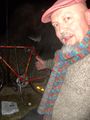
Thwarted by the golf course's fence and gate, and poor posture on the bike.
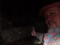
Gold Creek Country Club entrance at a bit after midnight.

Achievements
1PE (Canberra) earned the Consecutive geohash achievement
|
1PE (Canberra) earned the Midnight Geohash achievement
|
Consecutive
1PE (Canberra) earned the Frozen Geohash Achievement
|
Consecutive
1PE (Canberra) earned the Golf Geohash Achievement
|
1PE (Canberra) earned the Bicycle geohash achievement
|