Difference between revisions of "2012-10-04 55 37"
From Geohashing
imported>Vb ([live picture] 160m from the hash, work of beavers. [http://www.openstreetmap.org/?lat=55.82600000&lon=37.40020000&zoom=16&layers=B000FTF @55.8260,37.4002]) |
imported>Vb (→Photos) |
||
| Line 40: | Line 40: | ||
Image:2012-10-04_55_37_17-58-58-621.jpg | The hash is out there. 600m [http://www.openstreetmap.org/?lat=55.82990000&lon=37.39440000&zoom=16&layers=B000FTF @55.8299,37.3944] | Image:2012-10-04_55_37_17-58-58-621.jpg | The hash is out there. 600m [http://www.openstreetmap.org/?lat=55.82990000&lon=37.39440000&zoom=16&layers=B000FTF @55.8299,37.3944] | ||
| + | |||
| + | Image:2012-10-04_55_37_18-40-20-811.jpg | 120m to the hash [http://www.openstreetmap.org/?lat=55.83270000&lon=37.39510000&zoom=16&layers=B000FTF @55.8327,37.3951] | ||
| + | |||
| + | Image:2012-10-04_55_37_18-39-34-803.jpg | 14m to the hash - the is in the water [http://www.openstreetmap.org/?lat=55.82590000&lon=37.40200000&zoom=16&layers=B000FTF @55.8259,37.4020] | ||
Image:2012-10-04_55_37_18-37-46-583.jpg | 12m to the hash - Geohashdroid turns green. [http://www.openstreetmap.org/?lat=55.82580000&lon=37.40200000&zoom=16&layers=B000FTF @55.8258,37.4020] | Image:2012-10-04_55_37_18-37-46-583.jpg | 12m to the hash - Geohashdroid turns green. [http://www.openstreetmap.org/?lat=55.82580000&lon=37.40200000&zoom=16&layers=B000FTF @55.8258,37.4020] | ||
Image:2012-10-04_55_37_18-38-47-496.jpg | 12m [http://www.openstreetmap.org/?lat=55.82580000&lon=37.40200000&zoom=16&layers=B000FTF @55.8258,37.4020] | Image:2012-10-04_55_37_18-38-47-496.jpg | 12m [http://www.openstreetmap.org/?lat=55.82580000&lon=37.40200000&zoom=16&layers=B000FTF @55.8258,37.4020] | ||
| − | |||
| − | |||
| − | |||
| − | |||
Image:2012-10-04_55_37_18-45-03-000.jpg | 120m from the hash. [http://www.openstreetmap.org/?lat=55.82600000&lon=37.40020000&zoom=16&layers=B000FTF @55.8260,37.4002] | Image:2012-10-04_55_37_18-45-03-000.jpg | 120m from the hash. [http://www.openstreetmap.org/?lat=55.82600000&lon=37.40020000&zoom=16&layers=B000FTF @55.8260,37.4002] | ||
Revision as of 17:32, 4 October 2012
| Thu 4 Oct 2012 in 55,37: 55.8258864, 37.4022196 geohashing.info google osm bing/os kml crox |
Location
Participants
Plans
Expedition
Tracklog
Photos
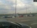
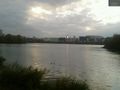
The hash is out there. 600m @55.8299,37.3944
120m to the hash @55.8327,37.3951
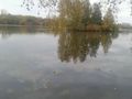
14m to the hash - the is in the water @55.8259,37.4020
12m to the hash - Geohashdroid turns green. @55.8258,37.4020
12m @55.8258,37.4020
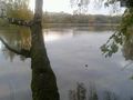
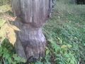
120m from the hash. @55.8260,37.4002
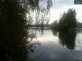
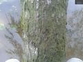
160m from the hash, work of beavers. @55.8260,37.4002


Achievements