Difference between revisions of "2012-10-06 55 37"
From Geohashing
imported>Vb ([live picture] End of the road [http://www.openstreetmap.org/?lat=55.84170000&lon=37.76290000&zoom=16&layers=B000FTF @55.8417,37.7629]) |
imported>Vb ([live picture] Leaving the trail [http://www.openstreetmap.org/?lat=55.85640000&lon=37.76000000&zoom=16&layers=B000FTF @55.8564,37.7600]) |
||
| Line 42: | Line 42: | ||
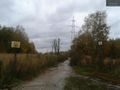
Image:2012-10-06_55_37_17-52-45-814.jpg | End of the road [http://www.openstreetmap.org/?lat=55.84170000&lon=37.76290000&zoom=16&layers=B000FTF @55.8417,37.7629] | Image:2012-10-06_55_37_17-52-45-814.jpg | End of the road [http://www.openstreetmap.org/?lat=55.84170000&lon=37.76290000&zoom=16&layers=B000FTF @55.8417,37.7629] | ||
| + | |||
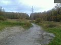
| + | Image:2012-10-06_55_37_18-14-55-867.jpg | Leaving the trail [http://www.openstreetmap.org/?lat=55.85640000&lon=37.76000000&zoom=16&layers=B000FTF @55.8564,37.7600] | ||
</gallery> | </gallery> | ||
Revision as of 14:16, 6 October 2012
| Sat 6 Oct 2012 in 55,37: 55.8559654, 37.7559718 geohashing.info google osm bing/os kml crox |
Location
Participants
Plans
Expedition
Tracklog
Photos
Entering Losiniy ostrov @55.8298,37.7644
End of the road @55.8417,37.7629
Leaving the trail @55.8564,37.7600


Achievements