Difference between revisions of "2012-10-13 42 -89"
From Geohashing
imported>Swensonj (gallery, achievements, and categories) |
imported>Swensonj (→Achievements: fix "tracklog" link in Tron achievement) |
||
| Line 68: | Line 68: | ||
| longitude = -89 | | longitude = -89 | ||
| date = 2012-10-13 | | date = 2012-10-13 | ||
| − | | tracklog = 2012-10-13_42_-89_Tron.png | + | | tracklog = http://wiki.xkcd.com/geohashing/File:2012-10-13_42_-89_Tron.png |
| possessive = his | | possessive = his | ||
| name = SwensonJ | | name = SwensonJ | ||
Revision as of 23:07, 13 October 2012
| Sat 13 Oct 2012 in 42,-89: 42.6545215, -89.9964695 geohashing.info google osm bing/os kml crox |
Location
Farmland east of Darlington, Wisconsin, off County Highway M
Participants
Plans
This is about as close to my home (Platteville, WI) as a hash can be in the Rockford, Illinois graticule. I'm trying for the XKCD meetup: Saturday at 4 p.m.
Expedition
Success! Writeup will follow....
Photos
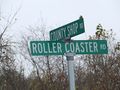
"Roller Coaster Road" was well named!
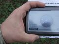
We made it!
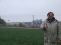
SwensonJ at hash
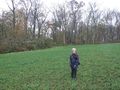
SwensonJ's son at hash
We were there for the 4 p.m. Saturday meetup...
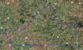
...and went home through Mineral Point, WI, to finish the Tron achievement


Achievements
SwensonJ earned the Land geohash achievement
|
SwensonJ earned the Consecutive geohash achievement
|
SwensonJ achieved level 4 of the Minesweeper Geohash achievement
|
SwensonJ earned the Tron achievement
|