Difference between revisions of "2012-10-13 32 -116"
From Geohashing
imported>LucasBrown ([live picture] (LucasBrown) Geohash Droid map at the hashpoint [http://www.openstreetmap.org/?lat=32.67180893&lon=-117.01210268&zoom=16&layers=B000FTF @32.6718,-117.0121]) |
imported>LucasBrown ([live picture] The hashpoint is under this tree. [http://www.openstreetmap.org/?lat=32.65450000&lon=-116.99600000&zoom=16&layers=B000FTF @32.6545,-116.9960]) |
||
| Line 42: | Line 42: | ||
Image:2012-10-13_32_-116_14-25-24-076.jpg | ([[User:LucasBrown|LucasBrown]]) Geohash Droid map at the hashpoint [http://www.openstreetmap.org/?lat=32.67180893&lon=-117.01210268&zoom=16&layers=B000FTF @32.6718,-117.0121] | Image:2012-10-13_32_-116_14-25-24-076.jpg | ([[User:LucasBrown|LucasBrown]]) Geohash Droid map at the hashpoint [http://www.openstreetmap.org/?lat=32.67180893&lon=-117.01210268&zoom=16&layers=B000FTF @32.6718,-117.0121] | ||
| + | |||
| + | Image:2012-10-13_32_-116_14-28-59-823.jpg | The hashpoint is under this tree. [http://www.openstreetmap.org/?lat=32.65450000&lon=-116.99600000&zoom=16&layers=B000FTF @32.6545,-116.9960] | ||
</gallery> | </gallery> | ||
Revision as of 21:29, 13 October 2012
| Sat 13 Oct 2012 in 32,-116: 32.6545215, -116.9964695 geohashing.info google osm bing/os kml crox |
Location
Participants
Plans
Expedition
Tracklog
Photos
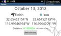
(LucasBrown) Geohash Droid details page at the hashpoint @32.6690,-117.0099
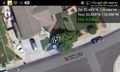
(LucasBrown) Geohash Droid map at the hashpoint @32.6718,-117.0121
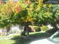
The hashpoint is under this tree. @32.6545,-116.9960


Achievements