Difference between revisions of "2012-12-05 36 -114"
From Geohashing
imported>Thomcat ([live] Worse news - 212 only every hour. On 402 which gets close. Do I walk it?) |
imported>Thomcat (Never a good sign. Then there's the lady I met there who told me there are coyotes. [http://www.openstreetmap.org/?lat=36.07174346&lon=-114.99176451&zoom=16&layers=B000FTF @36.0717,-114.9918]) |
||
| Line 32: | Line 32: | ||
--> | --> | ||
<gallery perrow="5"> | <gallery perrow="5"> | ||
| + | |||
| + | Image:2012-12-05_36_-114_16-31-28-112.jpg | Never a good sign. Then there's the lady I met there who told me there are coyotes. [http://www.openstreetmap.org/?lat=36.07174346&lon=-114.99176451&zoom=16&layers=B000FTF @36.0717,-114.9918] | ||
</gallery> | </gallery> | ||
Revision as of 00:31, 6 December 2012
| Wed 5 Dec 2012 in Mesquite: 36.0914459, -114.9905048 geohashing.info google osm bing/os kml crox |
Location
Just north of the Pabco trailhead, north of Henderson.
Participants
Plans
Take the 212 bus east from the South Strip transfer, get off at Pabco and Sunset, and walk north.
Expedition
- Missed the 3:00 bus east, next one in 20. Will I reach the geohash in daylight? -- Thomcat @36.0683,-115.1657 15:09, 5 December 2012 (PST)
- Worse news - 212 only every hour. On 402 which gets close. Do I walk it? -- Thomcat @36.0663,-115.0666 15:52, 5 December 2012 (PST)
Tracklog
Photos
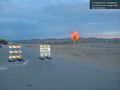
Never a good sign. Then there's the lady I met there who told me there are coyotes. @36.0717,-114.9918

Achievements