Difference between revisions of "2012-12-22 41 -111"
From Geohashing
imported>Tjjc4 (→Location) |
imported>Tjjc4 (→Participants) |
||
| Line 24: | Line 24: | ||
<!-- who attended: If you link to your wiki user name in this section, your expedition will be picked up by the various statistics generated for geohashing. You may use three tildes ~ as a shortcut to automatically insert the user signature of the account you are editing with. | <!-- who attended: If you link to your wiki user name in this section, your expedition will be picked up by the various statistics generated for geohashing. You may use three tildes ~ as a shortcut to automatically insert the user signature of the account you are editing with. | ||
--> | --> | ||
| + | [[User:tjjc4|Teancum]]<br> | ||
| + | Leslie<br> | ||
== Plans == | == Plans == | ||
Revision as of 05:17, 23 December 2012
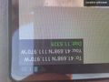
| Sat 22 Dec 2012 in 41,-111: 41.6976274, -111.9700279 geohashing.info google osm bing/os kml crox |
Location
The hash was located in a field east of the LDS church in Benson, Utah.
Participants
Teancum
Leslie
Plans
Expedition
Tracklog
Photos
You're there! This is as close to the point as GPS accuracy gets. Yay!
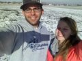
Teancum and Leslie
Proof of arrival!!


Achievements
Teancum Quist and Leslie Trippler earned the Frozen Geohash Achievement
|
Teancum Quist and Leslie Trippler earned the Earliest geohasher achievement
|
Teancum Quist earned the Drag-along achievement
|
Teancum Quist and Leslie Trippler earned the Land geohash achievement
|