Difference between revisions of "2012-12-23 29 -82"
From Geohashing
imported>Grumpa (→Photos) |
imported>Grumpa (→Photos) |
||
| Line 41: | Line 41: | ||
Image:2012-12-23_29_-82_05.jpg| Second pass...about 5400' for the Mile High. Came within 70' this time. Still respectable considering I'm a mile high. | Image:2012-12-23_29_-82_05.jpg| Second pass...about 5400' for the Mile High. Came within 70' this time. Still respectable considering I'm a mile high. | ||
Image:2012-12-23_29_-82_06.jpg| Oblique view of my two passes showing the relative elevation. Hashpoint labeled GNV. | Image:2012-12-23_29_-82_06.jpg| Oblique view of my two passes showing the relative elevation. Hashpoint labeled GNV. | ||
| − | Image:2012-12-23_29_-82_07.jpg| Overhead view of the two passes. The 360 over Archer was because I realized I wouldn't have the altitude for the Mile High. | + | Image:2012-12-23_29_-82_07.jpg| Overhead view of the two passes. The whole bit out to the west, changing colors, is me climbing from 1300' to 5400'. The 360 over Archer was because I realized I wouldn't have the altitude for the Mile High. |
</gallery> | </gallery> | ||
Revision as of 14:42, 24 December 2012
| Sun 23 Dec 2012 in 29,-82: 29.5585921, -82.5100048 geohashing.info google osm bing/os kml crox |
Location
Participants
Plans
Expedition
Tracklog
Photos
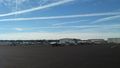
Georgeous day for flying!
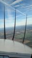
Note the contrail going from upper left of picture. You can see its shadow on the ground. I love flying.
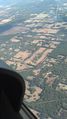
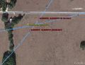
Approximate location of hash point
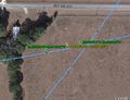
First pass at about 1300'. Yellow is the hash point. Measuring from Google Earth I came within 7' of the point. I amazed myself.
Second pass...about 5400' for the Mile High. Came within 70' this time. Still respectable considering I'm a mile high.
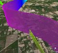
Oblique view of my two passes showing the relative elevation. Hashpoint labeled GNV.
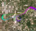
Overhead view of the two passes. The whole bit out to the west, changing colors, is me climbing from 1300' to 5400'. The 360 over Archer was because I realized I wouldn't have the altitude for the Mile High.


Achievements