imported>Grumpa |
imported>Grumpa |
| Line 17: |
Line 17: |
| | __NOTOC__ | | __NOTOC__ |
| | == Location == | | == Location == |
| − | <!-- where you've surveyed the hash to be -->
| + | West of Gainesville on the outskirts of the sprawling metropolis of Archer. |
| | | | |
| | == Participants == | | == Participants == |
| − | <!-- who attended: If you link to your wiki user name in this section, your expedition will be picked up by the various statistics generated for geohashing. You may use three tildes ~ as a shortcut to automatically insert the user signature of the account you are editing with.
| + | [[User:Grumpa|Grumpa]] |
| − | -->
| |
| | | | |
| | == Plans == | | == Plans == |
| − | <!-- what were the original plans -->
| + | Fly over the hash at low altitude then climb to 5280'+ AGL for the Mile High achievement |
| | | | |
| | == Expedition == | | == Expedition == |
| − | <!-- how it all turned out. your narrative goes here. -->
| + | To be updated soon. |
| | | | |
| − | == Tracklog ==
| |
| − | <!-- if your GPS device keeps a log, you may post a link here -->
| |
| | | | |
| | == Photos == | | == Photos == |
Revision as of 14:45, 24 December 2012
Location
West of Gainesville on the outskirts of the sprawling metropolis of Archer.
Participants
Grumpa
Plans
Fly over the hash at low altitude then climb to 5280'+ AGL for the Mile High achievement
Expedition
To be updated soon.
Photos
Georgeous day for flying!
Note the contrail going from upper left of picture. You can see its shadow on the ground. I love flying.
Approximate location of hash point
First pass at about 1300'. Yellow is the hash point. Measuring from Google Earth I came within 7' of the point. I amazed myself.
Second pass...about 5400' for the Mile High. Came within 70' this time. Still respectable considering I'm a mile high.
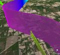
Oblique view of my two passes showing the relative elevation. Hashpoint labeled GNV.
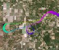
Overhead view of the two passes. The whole bit out to the west, changing colors, is me climbing from 1300' to 5400'. The 360 over Archer was because I realized I wouldn't have the altitude for the Mile High.
Achievements


