Difference between revisions of "2013-03-10 48 11"
From Geohashing
imported>Knallgöwer (→Location) |
imported>Knallgöwer (→Expedition) |
||
| Line 33: | Line 33: | ||
| − | * | + | *Wow! I started in Munich with heavy pouring rain and as I get closer to the hash the sun comes out. -- [[User:Knallgöwer|Knallgöwer]] ([[User talk:Knallgöwer|talk]]) [http://www.openstreetmap.org/?lat=47.97189703&lon=11.76257685&zoom=16&layers=B000FTF @47.9719,11.7626] 09:41, 10 March 2013 (CET) |
| − | |||
== Tracklog == | == Tracklog == | ||
<!-- if your GPS device keeps a log, you may post a link here --> | <!-- if your GPS device keeps a log, you may post a link here --> | ||
Revision as of 12:34, 11 March 2013
| Sun 10 Mar 2013 in 48,11: 48.0379557, 11.8232070 geohashing.info google osm bing/os kml crox |
Location
In a forest close to the small village Niederpframmen east of Munich.
Participants
Plans
Expedition
- Wow! I started in Munich with heavy pouring rain and as I get closer to the hash the sun comes out. -- Knallgöwer (talk) @47.9719,11.7626 09:41, 10 March 2013 (CET)
Tracklog
Photos
As close to the hash as possible...
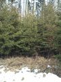
The hash is 15 meters into that thick woods
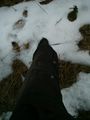
Wet trousers
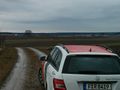
Nice view of the alps (not really visible on the pic :-) )


Achievements