Difference between revisions of "2013-03-26 49 9"
From Geohashing
imported>Chemluth (Created page with " <!-- If you did not specify these parameters in the template, please substitute appropriate values for IMAGE, LAT, LON, and DATE (YYYY-MM-DD format) [[Image:{{{image|IMAGE}...") |
imported>Chemluth |
||
| Line 49: | Line 49: | ||
== Achievements == | == Achievements == | ||
| − | |||
{{#vardefine:ribbonwidth|800px}} | {{#vardefine:ribbonwidth|800px}} | ||
<!-- Add any achievement ribbons you earned below, or remove this section --> | <!-- Add any achievement ribbons you earned below, or remove this section --> | ||
Revision as of 13:50, 27 March 2013
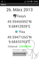
| Tue 26 Mar 2013 in 49,9: 49.5946699, 9.6841293 geohashing.info google osm bing/os kml crox |
Location
Above the Tauber near Distelhausen.
Participants
Plans
I did not really plan it I just noticed that I would pass throuh Distelhausen anyway and decidet to give it a try.
Expedition
I started walking at the football (soccer for our american friends) field and crossed a brigde over the river Tauber. I was already pritty dark and I didn´t find find the way Saw on the satelite picture. So I just went up the hill following the GPS. I crossed a railroad track and hat to make my way through thorny bushes and climb the steep hill towards the forrest. The hashpoint was about 10 Meters inside the woods.
Tracklog
Photos
- 2013-03-26 49 9 Bridge.jpg
Bridge over the Tauber
- 2013-03-26 49 9 Railway.jpg
The railway tracks I crossed
- 2013-03-26 49 9 Proof.jpg

Achievements