Difference between revisions of "2013-03-28 38 -77"
From Geohashing
imported>OfficeLinebacker (→Location) |
imported>OfficeLinebacker ([live picture] Trail in the woods [http://www.openstreetmap.org/?lat=38.67179937&lon=-77.17065448&zoom=16&layers=B000FTF @38.6718,-77.1707]) |
||
| Line 47: | Line 47: | ||
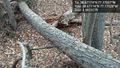
Image:2013-03-28_38_-77_10-58-21-677.jpg | I got to cross this natural bridge to teach the location [http://www.openstreetmap.org/?lat=38.67174035&lon=-77.17028315&zoom=16&layers=B000FTF @38.6717,-77.1703] | Image:2013-03-28_38_-77_10-58-21-677.jpg | I got to cross this natural bridge to teach the location [http://www.openstreetmap.org/?lat=38.67174035&lon=-77.17028315&zoom=16&layers=B000FTF @38.6717,-77.1703] | ||
| + | |||
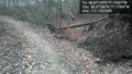
| + | Image:2013-03-28_38_-77_11-03-30-929.jpg | Trail in the woods [http://www.openstreetmap.org/?lat=38.67179937&lon=-77.17065448&zoom=16&layers=B000FTF @38.6718,-77.1707] | ||
</gallery> | </gallery> | ||
Revision as of 15:03, 28 March 2013
| Thu 28 Mar 2013 in 38,-77: 38.6717396, -77.1702692 geohashing.info google osm bing/os kml crox |
Location
In some woods next to the parking lot for Pirates Cove waterpark in Lorton VA. Apparently they store RVs here in the offseason.
Participants
Plans
Expedition
- In a forest near Pirate's Cove waterpark in Lorton, VA -- OfficeLinebacker (talk) @39.0931,-77.1553 09:43, 28 March 2013 (EDT)
Tracklog
Photos

Silly grin @38.6717,-77.1703
Crossing the bridge @38.6717,-77.1703
I got to cross this natural bridge to teach the location @38.6717,-77.1703
Trail in the woods @38.6718,-77.1707


Achievements