Difference between revisions of "2013-04-28 51 -0"
imported>KennethCC (→Location) |
imported>KennethCC (→Achievements) |
||
| Line 57: | Line 57: | ||
{{#vardefine:ribbonwidth|800px}} | {{#vardefine:ribbonwidth|800px}} | ||
<!-- Add any achievement ribbons you earned below, or remove this section --> | <!-- Add any achievement ribbons you earned below, or remove this section --> | ||
| + | {{land geohash | latitude = 51 | longitude = -0 | date = 2013-04-28 | name = Kenneth | image = 2013-04-28 51 -0 15-43-33-345.jpg }} | ||
Revision as of 17:32, 1 May 2013
| Sun 28 Apr 2013 in 51,-0: 51.2958254, -0.4715725 geohashing.info google osm bing/os kml crox |
Location
A muddied rut at the side of a narrow country lane outside Ockham in Surrey.
Participants
Plans
Walk from Staines, taking a scenic route, until I reach the coordinates. It looked like a nice day and there was nothing of immediate urgency that needed doing elsewhere. Once there, send in an update via the andriod "Geohash Driod" app, then find a pub to get something to eat and take a leisurely walk back home.
Expedition
- Reached the coords. Muddy ditch by the side of a narrow country lane. Walked +20 miles to get here, but satisfied - now, to get back. :-) -- KennethCC (talk) @51.2958,-.4717 10:38, 28 April 2013 (EDT)
I spent a couple hours after the coords were reached heading generally North back towards Staines and hoping to come across a pub. The whole trip had been very light on the use of maps and I had generally headed South-West knowing I would need to swing around East somewhere around Woking. I checked the GPS map on my phone every hour or so, though I do get distracted, and would wander off down interesting looking paths. The trip there, I had estimated to be between 13 and 14 miles; it made a little over 21 do the job though. The trip back was more of the same although I did manage to bruise the bottom of one foot and so had to limp the last seven or so miles back. In fact, I am just about recovered now (Thu 1ST May).
A pleasant day out; I ended up sore and wind-burned and the final tally was just under 45 miles (don't ask how I managed to add all those extra miles onto the return trip as well - it was a day out damn it, all to myself!).
Tracklog
Photos
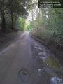
In this puddle; as near as can be made out. @51.2958,-.4716

Obligatory selfie. @51.2958,-.4716


Achievements
Kenneth earned the Land geohash achievement
|