Difference between revisions of "2013-05-25 52 -1"
imported>Nickholden (→Tracklog) |
imported>Nickholden (→Photos) |
||
| Line 34: | Line 34: | ||
Image:2012-##-## ## ## Alpha.jpg | Witty Comment | Image:2012-##-## ## ## Alpha.jpg | Witty Comment | ||
--> | --> | ||
| − | <gallery perrow=" | + | <gallery perrow="4"> |
| + | Image:20130525-1725-field.jpg | The geohash is in the centre of this field | ||
| + | Image:20130525-1725-close-enough.jpg | The internet was here... in the field | ||
| + | Image:20130525-1731-crop.jpg | These little baby sweetcorn were occupying the field | ||
| + | Image:IMG00751-20130525-1743.jpg | Geohashing to the centre of the ... country. Good pick for #towelday | ||
</gallery> | </gallery> | ||
Revision as of 22:39, 25 May 2013
| Sat 25 May 2013 in Birmingham: 52.7289758, -1.5523316 geohashing.info google osm bing/os kml crox |
Location
In a farmer's field north-east of Moira, on the border between Leicestershire and Derbyshire, UK.
Participants
Plans
Aiming for a 4pm meetup. Bring a towel. This will be my first hash with my new phone, and also my longest return bike journey, so there's plenty of potential for disaster. Fans of chaos should probably attend.
A toast! Quiet! Shut up! I'm ah, I got words. I'm saying. This is an auspicious day. We all know what day it is.
- What's auspicious? What day is it?
A glorious day for all the proud members of the allied planets. #towelday and #mouseoverday
Expedition
Well, the good news is I got there. But two punctures on the way didn't help - and it turns out 30 miles up and down hills takes a lot longer than 30 miles on the flat. Yeah, I know, that's kind of obvious, right? So I got there late for the meetup. Not that anyone else turned up. A nice man in the neighbouring cottage directed me into the right field, and I got as close as the newly-planted growing crop would allow. I'm calling it a success.
Tracklog
I've put the route to the geohash on Strava: http://app.strava.com/activities/56247197
Photos
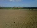
The geohash is in the centre of this field
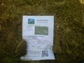
The internet was here... in the field
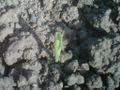
These little baby sweetcorn were occupying the field
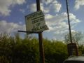
Geohashing to the centre of the ... country. Good pick for #towelday


Achievements