Difference between revisions of "2008-05-23 52 4"
From Geohashing
imported>Ath |
imported>Polysylabic Pseudonym (Categorising.) |
||
| Line 13: | Line 13: | ||
Image:2008-05-23_52_4_View_on_golfcourse.jpg|The other side of the dike showed the Houtrak golfcourse | Image:2008-05-23_52_4_View_on_golfcourse.jpg|The other side of the dike showed the Houtrak golfcourse | ||
</gallery> | </gallery> | ||
| + | |||
| + | [[Category:Expeditions with photos]] | ||
| + | [[Category:Expeditions]] | ||
Revision as of 04:43, 27 May 2008
| Fri 23 May 2008 in 52,4: 52.4002469, 4.7227719 geohashing.info google osm bing/os kml crox |
Friday afternoon after work, the geohashing location of graticule (52,4) was reached by Niels. Just because it was a 5 minute drive from his home. The location was at Houtrak, inbetween Amsterdam and Spaarnwoude, in a field right outside the Houtrak golfcourse.
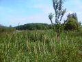
Hard to reach in the middle of a field
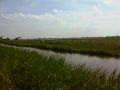
View on the location from a near dike.
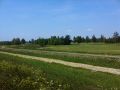
The other side of the dike showed the Houtrak golfcourse


