Difference between revisions of "2013-07-07 39 -76"
From Geohashing
imported>OfficeLinebacker (→Plans) |
imported>OfficeLinebacker (→Expedition) |
||
| Line 34: | Line 34: | ||
<!-- how it all turned out. your narrative goes here. --> | <!-- how it all turned out. your narrative goes here. --> | ||
| + | We thought there was a sidewalk there but there wasn't. We pulled over onto Hilltop and when we parked, outside of a fence but on the same grassy area as some equipment, a man watering plants inside the fen e gave us the evil eye. I asked if this was his property and the fact that i asked made him lighten up and he waved dismissively. We proceeded to the ha).s point (the has point itself was not on private property, just the verge where we pulled over | ||
| − | |||
== Tracklog == | == Tracklog == | ||
<!-- if your GPS device keeps a log, you may post a link here --> | <!-- if your GPS device keeps a log, you may post a link here --> | ||
Revision as of 20:16, 7 July 2013
| Sun 7 Jul 2013 in 39,-76: 39.1754668, -76.5963789 geohashing.info google osm bing/os kml crox |
Location
On a corner in Point Pleasant, MD, close to Marley Creek
Participants
- Allison
- OfficeLinebacker (talk)
Plans
To drive there, get the hash, then explore a bit
Expedition
We thought there was a sidewalk there but there wasn't. We pulled over onto Hilltop and when we parked, outside of a fence but on the same grassy area as some equipment, a man watering plants inside the fen e gave us the evil eye. I asked if this was his property and the fact that i asked made him lighten up and he waved dismissively. We proceeded to the ha).s point (the has point itself was not on private property, just the verge where we pulled over
Tracklog
Photos

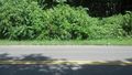
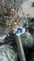
Made it" @39.1754,-76.5964
That's the exact spot
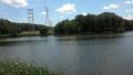
The famous Marley Creek
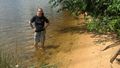
Allison wading in Marley Creek
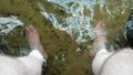
Dipping the toes in the water
Shoes safe and dry


Achievements