Difference between revisions of "2013-07-15 55 37"
From Geohashing
imported>Vb ([live] ~18km walk, half of it in the rain.) |
imported>Vb (→Location) |
||
| Line 19: | Line 19: | ||
== Location == | == Location == | ||
<!-- where you've surveyed the hash to be --> | <!-- where you've surveyed the hash to be --> | ||
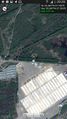
| + | What appears to be the north-east boundary of East Biryulevo district. | ||
== Participants == | == Participants == | ||
Revision as of 17:10, 15 July 2013
| Mon 15 Jul 2013 in 55,37: 55.5865881, 37.7034166 geohashing.info google osm bing/os kml crox |
Location
What appears to be the north-east boundary of East Biryulevo district.
Participants
Plans
Expedition
- ~18km walk, half of it in the rain. -- vb (talk) @55.5844,37.5594 13:07, 15 July 2013 (EDT)
Tracklog
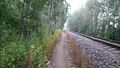
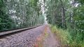
Photos
Coordinates reached.
At the hash.
Still at the hash
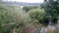
Not far away from the hash.


Achievements