Difference between revisions of "2013-08-12 37 -122"
From Geohashing
imported>Thomcat ([live picture] It's sunny in Sunnyvale [http://www.openstreetmap.org/?lat=37.36399139&lon=-122.01046112&zoom=16&layers=B000FTF @37.3640,-122.0105]) |
imported>Thomcat ([live picture] Dinner - still sunny [http://www.openstreetmap.org/?lat=37.35813438&lon=-122.01988816&zoom=16&layers=B000FTF @37.3581,-122.0199]) |
||
| Line 44: | Line 44: | ||
Image:2013-08-12_37_-122_17-33-15-479.jpg | It's sunny in Sunnyvale [http://www.openstreetmap.org/?lat=37.36399139&lon=-122.01046112&zoom=16&layers=B000FTF @37.3640,-122.0105] | Image:2013-08-12_37_-122_17-33-15-479.jpg | It's sunny in Sunnyvale [http://www.openstreetmap.org/?lat=37.36399139&lon=-122.01046112&zoom=16&layers=B000FTF @37.3640,-122.0105] | ||
| + | |||
| + | Image:2013-08-12_37_-122_18-14-57-552.jpg | Dinner - still sunny [http://www.openstreetmap.org/?lat=37.35813438&lon=-122.01988816&zoom=16&layers=B000FTF @37.3581,-122.0199] | ||
</gallery> | </gallery> | ||
Revision as of 01:15, 13 August 2013
| Mon 12 Aug 2013 in 37,-122: 37.3639954, -122.0104473 geohashing.info google osm bing/os kml crox |
Location
Participants
Plans
Headed there via #57 then #32 VTA bus. ETA 5:30-ish
Expedition
Tracklog
Photos
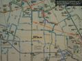
Bus route map - San Jose airport @37.3640,-121.9226
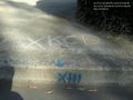
Curb message from Sunnyvale @37.3640,-122.0105

It's sunny in Sunnyvale @37.3640,-122.0105

Dinner - still sunny @37.3581,-122.0199


Achievements