Difference between revisions of "2013-09-06 45 -119"
From Geohashing
imported>Eldin (initial report) |
imported>Eldin (check categories and link expedition photos.) |
||
| Line 1: | Line 1: | ||
| − | |||
| − | |||
| − | |||
| − | |||
| − | |||
| − | |||
| − | |||
| − | |||
| − | |||
| − | |||
{{meetup graticule | {{meetup graticule | ||
| lat=45 | | lat=45 | ||
| Line 15: | Line 5: | ||
}} | }} | ||
| − | |||
__NOTOC__ | __NOTOC__ | ||
| Line 29: | Line 18: | ||
== Expedition == | == Expedition == | ||
I got off the interstate at an exit almost due south of the hash and took the road north. About a mile from the hash, which was about a half mile from the nearest approach of the road to the hash, I encountered a sign indicating that both sides of the road were private property for the next 3 miles, and that trespassing was forbidden. So I grabbed a photo of the sign, turned around, and continued on my way home. | I got off the interstate at an exit almost due south of the hash and took the road north. About a mile from the hash, which was about a half mile from the nearest approach of the road to the hash, I encountered a sign indicating that both sides of the road were private property for the next 3 miles, and that trespassing was forbidden. So I grabbed a photo of the sign, turned around, and continued on my way home. | ||
| − | |||
| − | |||
== Photos == | == Photos == | ||
| − | |||
| − | |||
| − | |||
<gallery perrow="5"> | <gallery perrow="5"> | ||
| + | File:2013-09-06 45 -119 sign.jpg | They seem to be mostly worried about hunters, but they mention trespassing as well. | ||
</gallery> | </gallery> | ||
| Line 43: | Line 28: | ||
{{No trespassing|date=2013-09-06|latitude=45|longitude=-119|name=[[User:Eldin|Eldin]]}} | {{No trespassing|date=2013-09-06|latitude=45|longitude=-119|name=[[User:Eldin|Eldin]]}} | ||
| − | |||
| − | |||
| − | |||
| − | |||
| − | |||
| − | |||
| − | |||
| − | |||
| − | |||
| − | |||
[[Category:Expeditions]] | [[Category:Expeditions]] | ||
| − | |||
[[Category:Expeditions with photos]] | [[Category:Expeditions with photos]] | ||
| − | |||
| − | |||
| − | |||
| − | |||
| − | |||
| − | |||
| − | |||
| − | |||
| − | |||
[[Category:Coordinates not reached]] | [[Category:Coordinates not reached]] | ||
| − | |||
| − | |||
| − | |||
| − | |||
| − | |||
[[Category:Not reached - No public access]] | [[Category:Not reached - No public access]] | ||
| − | |||
| − | |||
| − | |||
| − | |||
| − | |||
| − | |||
| − | |||
| − | |||
Revision as of 19:34, 7 September 2013
| Fri 6 Sep 2013 in 45,-119: 45.7931847, -119.1021079 geohashing.info google osm bing/os kml crox |
Location
Just north of I-84, east of Hermiston.
Participants
Plans
It was too close to the route back home from the coast to not try to get it.
Expedition
I got off the interstate at an exit almost due south of the hash and took the road north. About a mile from the hash, which was about a half mile from the nearest approach of the road to the hash, I encountered a sign indicating that both sides of the road were private property for the next 3 miles, and that trespassing was forbidden. So I grabbed a photo of the sign, turned around, and continued on my way home.
Photos
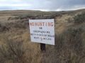
They seem to be mostly worried about hunters, but they mention trespassing as well.

Achievements
Eldin earned the No trespassing consolation prize
|