Difference between revisions of "2013-09-08 39 -120"
From Geohashing
imported>Zebburkeconte |
imported>Zebburkeconte |
||
| Line 49: | Line 49: | ||
Delete the next line ONLY if you have chosen the appropriate categories below. If you are unsure, don't worry. People will read your report and help you with the classification. --> | Delete the next line ONLY if you have chosen the appropriate categories below. If you are unsure, don't worry. People will read your report and help you with the classification. --> | ||
[[Category:New report]] | [[Category:New report]] | ||
| − | |||
| − | |||
| − | |||
| − | |||
| − | |||
| − | |||
[[Category:Expeditions]] | [[Category:Expeditions]] | ||
| − | |||
[[Category:Expeditions with photos]] | [[Category:Expeditions with photos]] | ||
| − | |||
| − | |||
| − | |||
| − | |||
| − | |||
| − | |||
| − | |||
| − | |||
[[Category:Coordinates not reached]] | [[Category:Coordinates not reached]] | ||
| − | |||
| − | |||
| − | |||
| − | |||
[[Category:Not reached - No public access]] | [[Category:Not reached - No public access]] | ||
Revision as of 14:25, 9 September 2013
| Sat 8 Sep 2012 in 39,-120: 39.8080342, -120.5599756 geohashing.info google osm bing/os kml crox |
Location
The hash is located in a field out in the middle of nowhere just off CA-70.
Participants
Zebburkeconte (talk) and father
Expedition
We drove out there, and when we saw how close it was to the highway, I thought we had hit the jackpot. However, once we started going to it we realized that the road that Google Maps said would take us there was really someone's driveway. We drove down it, but we were basically in this guy's backyard. He didn't look too friendly, and he had a dog. In the end we only got within 0.3 miles.
Photos
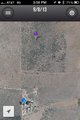
The closest we got
