Difference between revisions of "2013-10-13 32 -117"
From Geohashing
imported>LucasBrown (Geohash Droid details page at the hashpoint) |
imported>LucasBrown (Map at the hashpoint) |
||
| Line 27: | Line 27: | ||
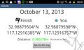
Image:2013-10-13_32_-117_22-05-48-728.jpg | Geohash Droid details page at the hashpoint | Image:2013-10-13_32_-117_22-05-48-728.jpg | Geohash Droid details page at the hashpoint | ||
| + | |||
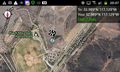
| + | Image:2013-10-13_32_-117_22-06-42-292.jpg | Map at the hashpoint | ||
</gallery> | </gallery> | ||
Revision as of 05:06, 14 October 2013
| Sun 13 Oct 2013 in 32,-117: 32.9887950, -117.1291639 geohashing.info google osm bing/os kml crox |
Location
Just off the eastern edge of Black Mountain Ranch Park in San Diego, CA
Participants
Plans
JesseW (talk): Dropping by sometime, not sure when.
Expedition
JesseW (talk): We arrived around 3 PM or so, got within GPS accuracy distance of the point, which is up on flat area next to a baseball field, with lots of very tall thistles scattered around. There's what looks like a model airplane landing area nearby. It was a good expidition.
Tracklog
Photos
Geohash Droid details page at the hashpoint
Map at the hashpoint


Achievements