Difference between revisions of "2014-03-02 34 -118"
From Geohashing
imported>Bravissimo594 (Changed categories from "New report" to "Expedition planning".) |
imported>Bravissimo594 m ([live picture] Geohash Droid success! [http://www.openstreetmap.org/?lat=34.84303212&lon=-118.41896092&zoom=16&layers=B000FTF @34.8430,-118.4190]) |
||
| Line 43: | Line 43: | ||
--> | --> | ||
<gallery perrow="5"> | <gallery perrow="5"> | ||
| + | |||
| + | Image:2014-03-02_34_-118_11-22-29-831.jpg | Geohash Droid success! [http://www.openstreetmap.org/?lat=34.84303212&lon=-118.41896092&zoom=16&layers=B000FTF @34.8430,-118.4190] | ||
</gallery> | </gallery> | ||
Revision as of 19:22, 2 March 2014
| Have you seen our geohashing marker? We'd love to hear from you! Click here to say "hi" and tell us what you've seen!
Curious about what geohashing is? Read more! |  |
| Sun 2 Mar 2014 in 34,-118: 34.8432415, -118.4196304 geohashing.info google osm bing/os kml crox |
Location
Desert land in the alluvial plains west of Rosamond. Los Angeles graticule.
Participants
Plans
Weather permitting, I expect to arrive sometime between 9:00am and 11:00am to give the puppies a chance to stretch their legs. Bravissimo594 (talk) 11:50, 28 February 2014 (EST)
Expedition
Tracklog
Photos
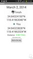
Geohash Droid success! @34.8430,-118.4190

Achievements