Difference between revisions of "2014-03-25 -35 149"
From Geohashing
imported>Palmpje m (Take off the new report cat) |
imported>FippeBot m (Location) |
||
| Line 82: | Line 82: | ||
(Don't forget to delete this final close comment marker) --> | (Don't forget to delete this final close comment marker) --> | ||
| + | {{location|AU|ACT}} | ||
Latest revision as of 05:59, 14 August 2019
| Tue 25 Mar 2014 in -35,149: -35.2843263, 149.1850711 geohashing.info google osm bing/os kml crox |
Location
The eastern verge of the new Majura Parkway.
Participants
Plans
Go by on the way home from work.
Expedition
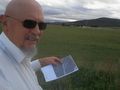
I always knew that it was going to be inaccessible, because it was on the far side of a farm and within the construction zone for the Majura Parkway road. So, I went to Majura Road (it's different) and took a picture looking west. See the building in the background. Find the left end. The hash is in line, even though you can't see the road construction from this low. I got as close as I could without trespassing.
Tracklog
Photos
It's away over the farmer's field, behind the farm buildings.
