Difference between revisions of "2014-04-02 -35 149"
From Geohashing
imported>1PE m (→Location) |
imported>1PE |
||
| Line 19: | Line 19: | ||
== Location == | == Location == | ||
In the middle of a rural property off Majura Road, near Canberra Airport. | In the middle of a rural property off Majura Road, near Canberra Airport. | ||
| − | Very near [[2013-09-11 -35 149]]. | + | Very near [[2013-09-11 -35 149]], and not far from [[2014-03-25 -35 149]]. |
== Participants == | == Participants == | ||
| − | + | * User:1PE|1PE]] | |
| − | |||
== Plans == | == Plans == | ||
| Line 30: | Line 29: | ||
== Expedition == | == Expedition == | ||
| − | + | I went to the farm gate. There was a very heavy chain on the gate. I left the hash coordinates sheet in the letterbox, having explained the Geohashing process on it. I was several hundred metres from the hash, but, as close as I was able to go by the owner, so, accordingly, I claim this hash. | |
== Tracklog == | == Tracklog == | ||
| Line 40: | Line 39: | ||
--> | --> | ||
<gallery perrow="5"> | <gallery perrow="5"> | ||
| + | Image:2014-04-02 -35 149 12.02.45.jpg|A locked gate, but the hash is out there behind my hand. | ||
</gallery> | </gallery> | ||
| Line 53: | Line 53: | ||
<!-- ==REQUEST FOR TWITTER BOT== Please leave either the New report or the Expedition planning category in as long as you work on it. This helps the twitter bot a lot with announcing the right outcome at the right moment. --> | <!-- ==REQUEST FOR TWITTER BOT== Please leave either the New report or the Expedition planning category in as long as you work on it. This helps the twitter bot a lot with announcing the right outcome at the right moment. --> | ||
| − | |||
| − | |||
| − | |||
| − | |||
[[Category:Expeditions]] | [[Category:Expeditions]] | ||
| − | |||
[[Category:Expeditions with photos]] | [[Category:Expeditions with photos]] | ||
| + | <!-- | ||
[[Category:Expeditions with videos]] | [[Category:Expeditions with videos]] | ||
[[Category:Expedition without GPS]] | [[Category:Expedition without GPS]] | ||
--> | --> | ||
| − | |||
| − | |||
| − | |||
| − | |||
| − | |||
[[Category:Coordinates not reached]] | [[Category:Coordinates not reached]] | ||
| − | |||
| − | |||
| − | |||
| − | |||
| − | |||
[[Category:Not reached - No public access]] | [[Category:Not reached - No public access]] | ||
| − | |||
| − | |||
| − | |||
| − | |||
| − | |||
| − | |||
| − | |||
| − | |||
Revision as of 06:41, 2 April 2014
| Wed 2 Apr 2014 in -35,149: -35.2631718, 149.2041533 geohashing.info google osm bing/os kml crox |
Location
In the middle of a rural property off Majura Road, near Canberra Airport. Very near 2013-09-11 -35 149, and not far from 2014-03-25 -35 149.
Participants
- User:1PE|1PE]]
Plans
1PE
- Lunchtime drive from work, and back.
Expedition
I went to the farm gate. There was a very heavy chain on the gate. I left the hash coordinates sheet in the letterbox, having explained the Geohashing process on it. I was several hundred metres from the hash, but, as close as I was able to go by the owner, so, accordingly, I claim this hash.
Tracklog
Photos
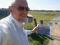
A locked gate, but the hash is out there behind my hand.
