Difference between revisions of "2014-04-03 51 12"
imported>TFTD (Page created) |
imported>TFTD (Content) |
||
| Line 19: | Line 19: | ||
== Location == | == Location == | ||
<!-- where you've surveyed the hash to be --> | <!-- where you've surveyed the hash to be --> | ||
| + | The hash is on a field near Mösthinsdorf and the railway line between Magdeburg and Halle. | ||
== Participants == | == Participants == | ||
<!-- who attended: If you link to your wiki user name in this section, your expedition will be picked up by the various statistics generated for geohashing. You may use three tildes ~ as a shortcut to automatically insert the user signature of the account you are editing with. | <!-- who attended: If you link to your wiki user name in this section, your expedition will be picked up by the various statistics generated for geohashing. You may use three tildes ~ as a shortcut to automatically insert the user signature of the account you are editing with. | ||
--> | --> | ||
| + | [[User:TFTD | TFTD]] | ||
== Plans == | == Plans == | ||
<!-- what were the original plans --> | <!-- what were the original plans --> | ||
| + | Take the bike and enjoy the weather and on the way back take a detour to the Petersberg. | ||
== Expedition == | == Expedition == | ||
<!-- how it all turned out. your narrative goes here. --> | <!-- how it all turned out. your narrative goes here. --> | ||
| + | I got up pretty late today and realized I forgott to check for the coordinates yesterday. So I did and realized that they were within a nice distance for a bike ride. So at about noon I started and rode there pretty strait. | ||
| + | |||
| + | Nothing spectacular happened besides that I learned a more optimal way tot he place than I used to take on previous occasions (bike rides to Magdeburg). Ones on the field it took me a little to find the coordinates. I didn't spend much time looking at googlemaps to get an idea about the distances from the road so my rough idea I had was off by 50 meters. | ||
| + | |||
| + | Took some pictures from the coordinates. Tried to get better pictures of the coordinates till my phone broke down (I really need to get a better battery) and rode to the Petersberg. I had a short lunchbreak and than rode back home. Short and nice workout. | ||
== Tracklog == | == Tracklog == | ||
| Line 38: | Line 46: | ||
--> | --> | ||
<gallery perrow="5"> | <gallery perrow="5"> | ||
| + | Image:2014-03-13_51-12_Petersberg.jpg | Picutre of the Petersberg while standing on the coordinates. | ||
| + | Image:2014-03-13_51-12_Moesthinsdorf.jpg | Picture towards Mösthinsdorf while standing on the coordinates. | ||
| + | Image:2014-03-13 51-12 proof.jpg | Coordinate Proof | ||
| + | Image:2014-03-13_51-12_Coordinates.jpg | My bike at the edge of the field. Coordinates in the back. Roughly 100m. | ||
| + | Image: 2014-03-13_51-12_panorama.jpg | A really bad quality 360° panorama while standing on the coordinates. | ||
</gallery> | </gallery> | ||
| Line 46: | Line 59: | ||
<!-- =============== USEFUL CATEGORIES FOLLOW ================ | <!-- =============== USEFUL CATEGORIES FOLLOW ================ | ||
| − | |||
| − | |||
| − | |||
| − | |||
| − | |||
| − | |||
| − | |||
| − | |||
| − | |||
| − | |||
| − | |||
[[Category:Expeditions]] | [[Category:Expeditions]] | ||
| − | + | [[Category:Expeditions with photos]] | |
| − | [[Category:Expeditions with photos]] | ||
| − | |||
| − | |||
| − | |||
| − | |||
| − | |||
[[Category:Coordinates reached]] | [[Category:Coordinates reached]] | ||
| − | |||
| − | |||
| − | |||
| − | |||
| − | |||
| − | |||
| − | |||
| − | |||
| − | |||
| − | |||
| − | |||
| − | |||
| − | |||
| − | |||
| − | |||
| − | |||
| − | |||
| − | |||
Revision as of 17:41, 3 April 2014
| Thu 3 Apr 2014 in 51,12: 51.6314503, 12.0418252 geohashing.info google osm bing/os kml crox |
Location
The hash is on a field near Mösthinsdorf and the railway line between Magdeburg and Halle.
Participants
Plans
Take the bike and enjoy the weather and on the way back take a detour to the Petersberg.
Expedition
I got up pretty late today and realized I forgott to check for the coordinates yesterday. So I did and realized that they were within a nice distance for a bike ride. So at about noon I started and rode there pretty strait.
Nothing spectacular happened besides that I learned a more optimal way tot he place than I used to take on previous occasions (bike rides to Magdeburg). Ones on the field it took me a little to find the coordinates. I didn't spend much time looking at googlemaps to get an idea about the distances from the road so my rough idea I had was off by 50 meters.
Took some pictures from the coordinates. Tried to get better pictures of the coordinates till my phone broke down (I really need to get a better battery) and rode to the Petersberg. I had a short lunchbreak and than rode back home. Short and nice workout.
Tracklog
Photos
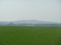
Picutre of the Petersberg while standing on the coordinates.
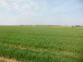
Picture towards Mösthinsdorf while standing on the coordinates.
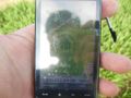
Coordinate Proof
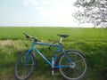
My bike at the edge of the field. Coordinates in the back. Roughly 100m.

A really bad quality 360° panorama while standing on the coordinates.


