Difference between revisions of "2014-04-25 51 -114"
From Geohashing
imported>Guzzby (→Photos) |
imported>Guzzby (→Photos) |
||
| Line 38: | Line 38: | ||
--> | --> | ||
<gallery perrow="5"> | <gallery perrow="5"> | ||
| − | Image:2014-04-25_51_-114_guzzby1.jpg | + | Image:2014-04-25_51_-114_guzzby1.jpg | Squishy time! |
| − | Image:2014-04-25_51_-114_guzzby2.jpg | + | Image:2014-04-25_51_-114_guzzby2.jpg | My Squishy |
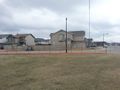
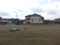
| − | Image:2014-04-25_51_-114_guzzby3.jpg | + | Image:2014-04-25_51_-114_guzzby3.jpg | View to the north |
| − | Image:2014-04-25_51_-114_guzzby4.jpg | + | Image:2014-04-25_51_-114_guzzby4.jpg | View to the east |
| − | Image:2014-04-25_51_-114_guzzby5.jpg | + | Image:2014-04-25_51_-114_guzzby5.jpg | View to the south |
| − | Image:2014-04-25_51_-114_guzzby6.jpg | + | Image:2014-04-25_51_-114_guzzby6.jpg | View to the west |
</gallery> | </gallery> | ||
Revision as of 20:11, 26 April 2014
| Fri 25 Apr 2014 in 51,-114: 51.0694246, -114.2170305 geohashing.info google osm bing/os kml crox |
Location
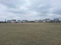
Calgary, Alberta Canada. On the field across the street from 625 Cougar Ridge Dr. SW
Participants
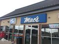
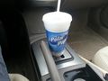
When I looked at eupeodes map this morning I saw it was possible to reach ground zero at two different graticules. I planned to leave at 10:00 am and drive to the one near Exshaw first. ThenI was going to drive back to the city and go out to Cougar Ridge where the second geohash is located . I was going to pick up a Squishee at the Mac's store which is 300 meters from the geohash. Then was going to look for 8 geocaches located in the area.
Expedition
Photos
Squishy time!
My Squishy
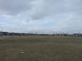
View to the north
View to the east
View to the south
View to the west


Achievements