Difference between revisions of "2014-05-21 49 10"
From Geohashing
imported>Schnatterfleck (→Participants) |
imported>Schnatterfleck (→Photos) |
||
| Line 47: | Line 47: | ||
Image:2014-05-21_49_10_Schnatterfleck_1400683097989.jpg | Really steep (more than it looks on the picture)... but also part of the calculated route. Fallback to pushing the bike (at least not carrying yet...) [http://www.openstreetmap.org/?lat=49.41240000&lon=10.90340000&zoom=16&layers=B000FTF @49.4124,10.9034] | Image:2014-05-21_49_10_Schnatterfleck_1400683097989.jpg | Really steep (more than it looks on the picture)... but also part of the calculated route. Fallback to pushing the bike (at least not carrying yet...) [http://www.openstreetmap.org/?lat=49.41240000&lon=10.90340000&zoom=16&layers=B000FTF @49.4124,10.9034] | ||
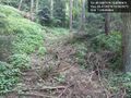
| − | Image:2014-05-21_49_10_Schnatterfleck_1400682812018.jpg | THIS is how I like it :) | + | Image:2014-05-21_49_10_Schnatterfleck_1400682812018.jpg | THIS is how I like it :) - But the near dead-end already lurked at the bottom of the little valley.... [http://www.openstreetmap.org/?lat=49.40950000&lon=10.89500000&zoom=16&layers=B000FTF @49.4095,10.8950] |
| − | But the near dead-end already lurked at the bottom of the little valley.... [http://www.openstreetmap.org/?lat=49.40950000&lon=10.89500000&zoom=16&layers=B000FTF @49.4095,10.8950] | ||
Image:2014-05-21_49_10_Schnatterfleck_1400680990831.jpg | Mission accomplished! [http://www.openstreetmap.org/?lat=49.36870000&lon=10.82880000&zoom=16&layers=B000FTF @49.3687,10.8288] | Image:2014-05-21_49_10_Schnatterfleck_1400680990831.jpg | Mission accomplished! [http://www.openstreetmap.org/?lat=49.36870000&lon=10.82880000&zoom=16&layers=B000FTF @49.3687,10.8288] | ||
Revision as of 05:06, 22 May 2014
| Wed 21 May 2014 in 49,10: 49.3687540, 10.8289638 geohashing.info google osm bing/os kml crox |
Location
A wood near Raitersaich
Participants
Plans
Expedition
Tracklog
Photos
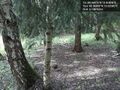
The hashpoint as located by my GPS - surprisingly nice area! Schnatterfleck @49.3688,10.8290
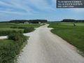
Aeaeah... Routing app?... You're kidding, right...?? @49.4128,10.9025

Really steep (more than it looks on the picture)... but also part of the calculated route. Fallback to pushing the bike (at least not carrying yet...) @49.4124,10.9034
THIS is how I like it :) - But the near dead-end already lurked at the bottom of the little valley.... @49.4095,10.8950
Mission accomplished! @49.3687,10.8288
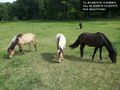
Not very far from the hash point. And I actually know those horses. @49.3699,10.8357
I was actually routed right through the middle of a golf course! @49.3781,10.9775


Achievements