Difference between revisions of "2014-09-17 49 8"
imported>DODO (→Tracklog) |
imported>DODO (→Photos) |
||
| Line 46: | Line 46: | ||
Image:2012-##-## ## ## Alpha.jpg | Witty Comment | Image:2012-##-## ## ## Alpha.jpg | Witty Comment | ||
--> | --> | ||
| − | <gallery perrow="5 | + | <gallery perrow="6"> |
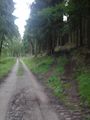
| + | Image:2014-09-17_49_8-1.jpg |These paths are not good enough for my bull (you can see it on the very left side) | ||
| + | Image:2014-09-17_49_8-2.jpg |the source. From here on everything went well | ||
| + | Image:2014-09-17_49_8-3.jpg |Eberbach deep beyond me | ||
| + | Image:2014-09-17_49_8-4.jpg |The Neckar valley | ||
| + | Image:2014-09-17_49_8-5.jpg |A juggernaut-waymark leads to the hashpoint | ||
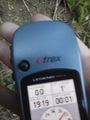
| + | Image:2014-09-17_49_8-6.jpg |proof | ||
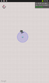
| + | Image:2014-09-17_49_8-7.png |another proof | ||
| + | Image:2014-09-17_49_8-8.jpg |view to the north (down to the juggernauts path) | ||
| + | Image:2014-09-17_49_8-9.jpg |and to the south steep upwards | ||
| + | Image:2014-09-17_49_8-10.jpg |stupid grin <sup>tm</sup> | ||
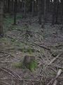
| + | Image:2014-09-17_49_8-11.jpg |a quick buid up mark | ||
</gallery> | </gallery> | ||
Revision as of 21:10, 17 September 2014
| Wed 17 Sep 2014 in 49,8: 49.4419596, 8.9884758 geohashing.info google osm bing/os kml crox |
Location
In the forest on a hill next to Eberbach.
Participants
DODOs most eastern hashpoint so far.
Plans
To ride there on my bull after work and have a short stop at spe stepdaughters spe husband.
Expedition
I got out of the office at half past four and reached Heidelberg around five o'clock. I left some luggage there (what was why I had to go to Heidelberg today) and some talking I headed on to the Neckar and the Neckarradweg (Neckar cycling route), which I followed for the next 40 KM or so. This is a strange cycling path including some very busy roads, some forest paths and even some staircases. Nevertheless I reached Eberbach (respectively the small part of it that lies on the left side of the river Neckar) at a quarter to seven or so. From here I had to leave the river and go into the forest. At first I could follow some steep streets upwards in the village, including - once again - some staircases (and its not really fun to carry a 30 kg bull up some staircases after cycling 2 hours). But soon I left the houses and entered the forest. What looks like a driveable path on the map turned out to be some very small, very steep and very rugged forest pathes and so I decided to tie my bull and continue by foot.
What I didn't know was that the hash was still 2 KM away and 300 m higher. I planned to take the train at 19:43 from Eberbach, but I soon gave up that plan. I was walking as fast as I could, but I was thirsty and the way was still steep. But then I suddenly reached a source, and after I drank some water I felt much better and headed on. It was a nice walk high above the Neckar valley with pretty views down. 50 m from the hashpoint a nuzzled path branched of in the direction of the hash. Did anyone try a juggernaut-achievement? Well, not exactly, that path missed the hash by 15 m , but it helped me to reach the hash quite convenient.
I reached the hash at exactly 19:20, took some pictures, and couldn't resist to build a marker, as some big branches were lying around. Then I hurried back to my bull, what was much easier, now the paths go downwards. I rode back to the Nackar (now circumscribing the staircase) crossed it and reached Eberbachs trainstation at 8 o'clock. The next train started at 20:29, so I had half an hour which I used to buy some ice-cream and some food and had a nice 1 1/2 hour-trip back home.
Tracklog
bull: 60 KM; walk: 4 KM; train: 69 KM
Photos
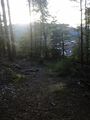
These paths are not good enough for my bull (you can see it on the very left side)
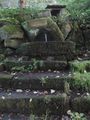
the source. From here on everything went well
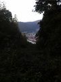
Eberbach deep beyond me
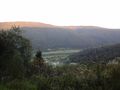
The Neckar valley
A juggernaut-waymark leads to the hashpoint
proof
another proof
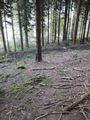
view to the north (down to the juggernauts path)
and to the south steep upwards
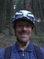
stupid grin tm
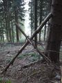
a quick buid up mark


Achievements