Difference between revisions of "2015-02-22 51 4"
From Geohashing
imported>FelixTheCat |
imported>FelixTheCat |
||
| Line 34: | Line 34: | ||
--> | --> | ||
<gallery perrow="5"> | <gallery perrow="5"> | ||
| − | Image:2015-02-22 51 4 FelixTheCat 3.jpg|The visitor map on the beach. The geohash is | + | Image:2015-02-22 51 4 FelixTheCat 3.jpg|The visitor map on the beach. The geohash is about 1/5 of the way between markers 8 and 9. |
Image:2015-02-22 51 4 FelixTheCat 2.jpg|This is marker 8.2. There's a marker every 200 metres along the beach. | Image:2015-02-22 51 4 FelixTheCat 2.jpg|This is marker 8.2. There's a marker every 200 metres along the beach. | ||
Image:2015-02-22 51 4 FelixTheCat 1.jpg|Lloyd posing for a photo at the geohash. | Image:2015-02-22 51 4 FelixTheCat 1.jpg|Lloyd posing for a photo at the geohash. | ||
Revision as of 18:34, 25 February 2015
| Sun 22 Feb 2015 in 51,4: 51.8986501, 4.0406906 geohashing.info google osm bing/os kml crox |
Location
On the beach outside Oostvoorne, The Netherlands
Participants
Plans
Nice sunny Sunday, perfect for a walk on the beach. And with the hashpoint on a nearby beach, that's exactly what I set out to do.
Expedition
Arrived at the beach around 14:30. Since I don't have any portable GPS-enabled devices, I had printed the location on Google Maps, hoping to find some landmarks that could help me pinpoint the exact location once there. Luckily, there was a visitor map that referenced markers on the beach. I'm pretty sure I ended up within 100 metres of the actual point.
Photos
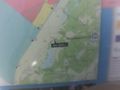
The visitor map on the beach. The geohash is about 1/5 of the way between markers 8 and 9.
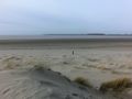
This is marker 8.2. There's a marker every 200 metres along the beach.
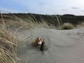
Lloyd posing for a photo at the geohash.


