Difference between revisions of "2015-06-07 49 8"
imported>DODO (→Photos) |
imported>DODO (→Tracklog) |
||
| Line 38: | Line 38: | ||
== Tracklog == | == Tracklog == | ||
<!-- if your GPS device keeps a log, you may post a link here --> | <!-- if your GPS device keeps a log, you may post a link here --> | ||
| + | [https://www.komoot.de/tour/5309427 103 KM by bull] and here including the [http://www.gpsies.com/map.do?fileId=rolmilhagfyqkxtc 52 KM train] | ||
== Photos == | == Photos == | ||
Revision as of 21:05, 7 June 2015
| Sun 7 Jun 2015 in 49,8: 49.0491659, 8.8822913 geohashing.info google osm bing/os kml crox |
Location
In the forest near Sternenfels/Kraichgau.
Participants
Plans
Go there on my bull. Making a detour over Mannheim to bring a key back to a friend. Hope to arrive there between 2 and 3 pm.
Expedition
Well, things worked pretty much out as planned. I started at home at 10:15 and had a quick ride to the south of Mannheim where I had a short stop at my friend to bring him back a key and stopped for a drink. After that I continued for a long ride. I entered the Kraichgau at Wiesloch and followed the valley of the Angelbach with a very smooth rise. Then I left the valley and a short hill later I entered the valley of the Elsenz. I left the Elsene at Mühlbach for another hill and when I reached Leonbronn I got a little bit exhausted. And exactly when I needed it most an ice cream parlour appeared. Some ice cream (the best lemon ice cream for years) and some beer later I continued my ride (although you never should eat the ice before the hash, but some exceptions has to be made).
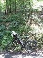
10 minutes later I parked the bull in the forest and had to climb a steep sloop upwards. 20 m later I decided to have reached my aim. I took some pictures and left a big X as a mark. Then I continued my ride to the train station in Bretten. I reached it at 15:05 so I got the 15:12 train back home.
Tracklog
103 KM by bull and here including the 52 KM train
Photos
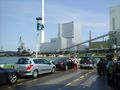
the (meanwhile famous) ferry once again
with the Heilbronner land I entered the Regierungsbezirk Stuttgart and finished the reverse regional hash on level 2 (Regierungsbezirke)

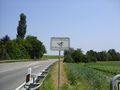
fortification for the last part
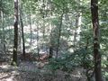
20m up there
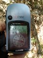
nearly exactly here
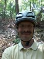
you find a happy hasher
down there is the way
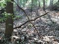
X


Achievements