Difference between revisions of "2015-07-11 51 4"
imported>FelixTheCat |
imported>FelixTheCat |
||
| Line 47: | Line 47: | ||
}} | }} | ||
| − | |||
| − | |||
| − | |||
| − | |||
| − | |||
| − | |||
| − | |||
| − | |||
| − | |||
| − | |||
| − | |||
| − | |||
[[Category:Expeditions]] | [[Category:Expeditions]] | ||
| − | |||
[[Category:Expeditions with photos]] | [[Category:Expeditions with photos]] | ||
| − | |||
| − | |||
| − | |||
| − | |||
| − | |||
| − | |||
| − | |||
| − | |||
| − | |||
[[Category:Coordinates not reached]] | [[Category:Coordinates not reached]] | ||
| − | |||
| − | |||
| − | |||
| − | |||
| − | |||
[[Category:Not reached - No public access]] | [[Category:Not reached - No public access]] | ||
| − | |||
| − | |||
| − | |||
| − | |||
| − | |||
| − | |||
| − | |||
| − | |||
Revision as of 20:09, 27 July 2015
| Sat 11 Jul 2015 in 51,4: 51.7579840, 4.7341191 geohashing.info google osm bing/os kml crox |
Location
Just inside Biesbosch National Park, Dordrecht.
Participants
Plans
Cycle to the hash and see if it's accessible.
Expedition
Today's hashpoint was located near Dordrecht, about 50 km from my house. I wanted to avoid having to ride through the centre of Rotterdam, so I planned a route through Delfgauw, the northern edge of Rotterdam, Capelle, Krimpen a/d Lek, Kinderdijk and Alblasserdam. The weather was nice and I made good progress. After touching the easternmost edge of Dordrecht I turned South and rode along the Nieuwe Merwede river towards the hash, which should be right on the riverbank.
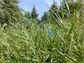
The river wasn't visible from the road, as there was a thick forest/swamp type of area in between. So when I reached the point where the hash should be, I parked my bike and tried to find a way into the forest. It was very thick with vegetation and there were swampy areas everywhere (and LOTS of flying insects), so I coulnd't walk to the hash directly. Luckily there was a footpath which I could follow, that eventually turned towards the river. Unfortunately there was still a small stream between it and the hashpoint, so I had to turn back and try reaching it from the other side. There was another path leading directly towards the river, but unfortunately there was a No Trespassing sign, with a Beware Of The Dog sign below. As it now seemed that the only remaining way to reach the point would require a boat, I decided to call it a day and got back on my bike again.
It was interesting to see such a remote part of South Holland province, and I covered a nice 112 km on my new commuting bike.
Photos
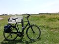
My new bike in the polder outside Delfgauw.
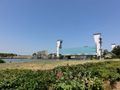
The Algera bridge crossing from Capelle to Krimpen a/d IJssel
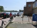
The ferry from Krimpen a/d Lek to Kinderdijk.
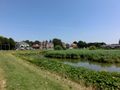
Entering Alblasserdam.
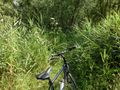
Entering the forest.
The hash should be about 400 metres ahead from here. So it's beyond the little stream right in front of me.
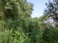
Trying to walk straight ahead from the road didn't work either. Not without a machete. Or a bulldozer.
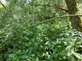
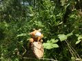
There was this completely overgrown footpath, but unfortunately it didn't take me any nearer the river either.
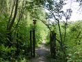
Finally, I found this gate, which although open, still had a quite clear "No Trespassing" sign next to it.
Lloyd posing for a picture at the nearest point I could get.


Achievements
FelixTheCat (talk) earned the No trespassing consolation prize
|