Difference between revisions of "2015-08-19 49 8"
imported>DODO (→Photos) |
imported>DODO (→Achievements) |
||
| Line 50: | Line 50: | ||
== Achievements == | == Achievements == | ||
{{#vardefine:ribbonwidth|800px}} | {{#vardefine:ribbonwidth|800px}} | ||
| − | + | {{No trespassing | |
| + | | latitude = 49 | ||
| + | | longitude = 8 | ||
| + | | date = 2015-08-19 | ||
| + | | name = DODO | ||
| + | | distance = 90m | ||
| − | + | }} | |
| − | |||
| − | |||
| − | |||
| − | |||
| − | |||
| − | |||
| − | |||
| − | |||
| − | |||
[[Category:Expeditions]] | [[Category:Expeditions]] | ||
| − | |||
[[Category:Expeditions with photos]] | [[Category:Expeditions with photos]] | ||
| − | |||
| − | |||
| − | |||
| − | |||
| − | |||
| − | |||
| − | |||
| − | |||
| − | |||
[[Category:Coordinates not reached]] | [[Category:Coordinates not reached]] | ||
| − | |||
| − | |||
| − | |||
| − | |||
| − | |||
[[Category:Not reached - No public access]] | [[Category:Not reached - No public access]] | ||
| − | |||
| − | |||
| − | |||
| − | |||
| − | |||
| − | |||
| − | |||
| − | |||
Revision as of 18:55, 19 August 2015
| Wed 19 Aug 2015 in 49,8: 49.5924958, 8.4890084 geohashing.info google osm bing/os kml crox |
Location
On a playground or something in Lampertheim.
Participants
Plans
Nowadays, it's not so easy for a man to go on a playground, but I will come close to the point. Let's see, how close I can get.
Expedition
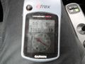
I had to drive little girl to the north this morning and on my way back to work I passed the hashpoint by 5 KM. To tempting, not to try. So I left the Autobahn in Mannheim- Sandhofen and drove to Lampertheim. I followed the arrow of my garmin until it points orthogonal to the road. There was a parking space on the small road and when I looked in the pointed direction I saw a high fence and the orange roof that I've seen on google. I could hear a lot of children and saw some movement through the fence, so I guess, there's a Kidergarden (yes, I've googled that, it's the Kindergarden of the catholic parish of Lampertheim). The hash wasn't reachable so obviously that I did not even get out of the car. I started again and continued my way to work. The whole detour costed me not more than 25 minutes.
Tracklog
Photos
stil far away
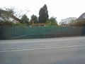
the orange roof may protect the hash

unhappy hasher


Achievements
DODO earned the No trespassing consolation prize
|