Difference between revisions of "2015-11-01 49 8"
imported>DODO (→Tracklog) |
imported>DODO (→Photos) |
||
| Line 43: | Line 43: | ||
Image:2012-##-## ## ## Alpha.jpg | Witty Comment | Image:2012-##-## ## ## Alpha.jpg | Witty Comment | ||
--> | --> | ||
| − | <gallery perrow=" | + | <gallery perrow="6"> |
| + | Image:2015-11-01_49_8-1.jpg|view to the hash (7 m into that field) | ||
| + | Image:2015-11-01_49_8-2.jpg|proof (didn't catch the 0) | ||
| + | Image:2015-11-01_49_8-3.jpg|view from hash to bull | ||
| + | Image:2015-11-01_49_8-4.jpg|view from hash to happy hasher | ||
| + | Image:2015-11-01_49_8-5.jpg|mark | ||
| + | Image:2015-11-01_49_8-6.jpg|bull with sunflowers and Bruchsal in the background | ||
</gallery> | </gallery> | ||
Revision as of 17:20, 1 November 2015
| Sun 1 Nov 2015 in 49,8: 49.1049902, 8.6330509 geohashing.info google osm bing/os kml crox |
Location
A field near Bruchsal.
Participants
Plans
It was already past 2 pm when I could start, and so I decided to go there on my bull. It's a 70 KM-ride so it will take almost 3 hours.
Expedition
Everything went pretty much as planned. I arrived in Bruchsal at a quarter past three and was close to the hashpoint some minutes later. I stopped the bull next to a field with sunflowers and rapeseed on the left, but the hash was on a harvested cornfield to my right. I only had to walk into the field for 7 m and reached a zero. I left a mark and continued my way home. At ten past five I reached home again.
Tracklog
Photos
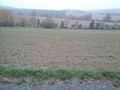
view to the hash (7 m into that field)
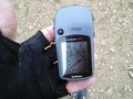
proof (didn't catch the 0)
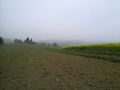
view from hash to bull
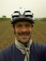
view from hash to happy hasher
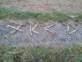
mark
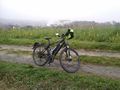
bull with sunflowers and Bruchsal in the background


Achievements