Difference between revisions of "2015-11-12 47 8"
From Geohashing
imported>Lysogeny (Plans, Lysogeny goes.) |
imported>Lysogeny (Maps.) |
||
| Line 30: | Line 30: | ||
<!-- what were the original plans --> | <!-- what were the original plans --> | ||
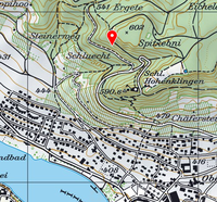
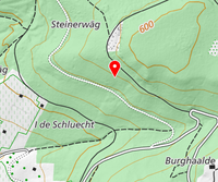
The hash seems to be on a hill-side. The incline should not be too steep, so it should be possible to reach the hash. | The hash seems to be on a hill-side. The incline should not be too steep, so it should be possible to reach the hash. | ||
| + | [[File:2015-11-11-154931_509x474_scrot.png|200px|thumb|left|map of where the hash is]] | ||
| + | [[File:2015-11-11-154945_467x391_scrot.png|200px|thumb|left|closeup]] | ||
== Expedition == | == Expedition == | ||
Revision as of 14:54, 11 November 2015
| Thu 12 Nov 2015 in 47,8: 47.6691404, 8.8565536 geohashing.info google osm bing/os kml crox |
Location
Hillside forest by Stein am Rhein, Switzerland
Participants
Plans
The hash seems to be on a hill-side. The incline should not be too steep, so it should be possible to reach the hash.
Expedition
Tracklog
Photos
Achievements

