Difference between revisions of "2016-04-09 59 18"
imported>Cjk ([live picture]Plaque [http://www.openstreetmap.org/?lat=59.60067500&lon=18.21123550&zoom=16&layers=B000FTF @59.6007,18.2112]) |
imported>Cjk |
||
| Line 2: | Line 2: | ||
<!-- If you did not specify these parameters in the template, please substitute appropriate values for IMAGE, LAT, LON, and DATE (YYYY-MM-DD format) | <!-- If you did not specify these parameters in the template, please substitute appropriate values for IMAGE, LAT, LON, and DATE (YYYY-MM-DD format) | ||
| − | [[Image:{{{image| | + | [[Image:{{{image|2016-04-09_59_18_cjk_1460215106909.jpg}}}|thumb|left]] |
Remove this section if you don't want an image at the top (left) of your report. You should remove the "Image:" or "File:" | Remove this section if you don't want an image at the top (left) of your report. You should remove the "Image:" or "File:" | ||
| Line 20: | Line 20: | ||
== Location == | == Location == | ||
<!-- where you've surveyed the hash to be --> | <!-- where you've surveyed the hash to be --> | ||
| + | In the woods near Gottröra, Sweden. | ||
== Participants == | == Participants == | ||
<!-- who attended: If you link to your wiki user name in this section, your expedition will be picked up by the various statistics generated for geohashing. You may use three tildes ~ as a shortcut to automatically insert the user signature of the account you are editing with. | <!-- who attended: If you link to your wiki user name in this section, your expedition will be picked up by the various statistics generated for geohashing. You may use three tildes ~ as a shortcut to automatically insert the user signature of the account you are editing with. | ||
--> | --> | ||
| + | [[User:Cjk|Cjk]] | ||
| + | |||
== Plans == | == Plans == | ||
<!-- what were the original plans --> | <!-- what were the original plans --> | ||
| + | Test drive my new car. | ||
== Expedition == | == Expedition == | ||
<!-- how it all turned out. your narrative goes here. --> | <!-- how it all turned out. your narrative goes here. --> | ||
| + | I was testing my new BMW and I open the droid it app and todays has was doable. Headed past Arlanda airport and off to the right fields. Turns out the hash was in a pine forest and they had been good at clearing out weeds so it was really open and easy to get to. 250m or so from the road. | ||
| + | *Hash -- [[User:Cjk|Cjk]] ([[User talk:Cjk|talk]]) [http://www.openstreetmap.org/?lat=59.65795400&lon=18.14971410&zoom=16&layers=B000FTF @59.6580,18.1497] 16:55, 9 April 2016 (GMT+02:00) | ||
| − | + | Headed back to the car and took a different way home. Had to stop at a rune stone on the way. | |
== Tracklog == | == Tracklog == | ||
<!-- if your GPS device keeps a log, you may post a link here --> | <!-- if your GPS device keeps a log, you may post a link here --> | ||
Revision as of 17:06, 14 April 2016
| Sat 9 Apr 2016 in 59,18: 59.6579399, 18.1496916 geohashing.info google osm bing/os kml crox |
Location
In the woods near Gottröra, Sweden.
Participants
Plans
Test drive my new car.
Expedition
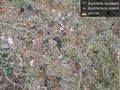
I was testing my new BMW and I open the droid it app and todays has was doable. Headed past Arlanda airport and off to the right fields. Turns out the hash was in a pine forest and they had been good at clearing out weeds so it was really open and easy to get to. 250m or so from the road.
- Hash -- Cjk (talk) @59.6580,18.1497 16:55, 9 April 2016 (GMT+02:00)
Headed back to the car and took a different way home. Had to stop at a rune stone on the way.
Tracklog
Photos
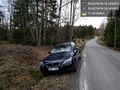
New car @59.6579,18.1495
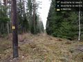
That way @59.6579,18.1498
Looking back @59.6579,18.1497

Fallen tree @59.6579,18.1497
Spring flowers @59.6579,18.1497
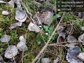
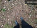
Deer poop @59.6579,18.1497
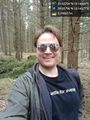
Me at hash @59.6580,18.1498
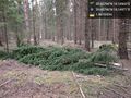
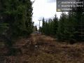
Trees @59.6580,18.1497
The hash @59.6580,18.1497
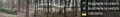
The panorama @59.6580,18.1497
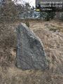
Runestone @59.6007,18.2112
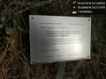
Plaque @59.6007,18.2112


Achievements