Difference between revisions of "2016-04-17 49 8"
imported>DODO (→Photos) |
imported>DODO (→Achievements) |
||
| Line 57: | Line 57: | ||
== Achievements == | == Achievements == | ||
{{#vardefine:ribbonwidth|800px}} | {{#vardefine:ribbonwidth|800px}} | ||
| − | |||
| − | + | {{mnb geohash | |
| − | + | | latitude = 49 | |
| − | + | | longitude = 8 | |
| + | | date = 2016-04-17 | ||
| + | | name = DODO | ||
| + | | image = 2016-04-17_49_8-05.jpg | ||
| + | }} | ||
| − | |||
| − | |||
| − | |||
| − | |||
| − | |||
| − | |||
[[Category:Expeditions]] | [[Category:Expeditions]] | ||
| − | + | ||
[[Category:Expeditions with photos]] | [[Category:Expeditions with photos]] | ||
| − | |||
| − | |||
| − | |||
| − | |||
| − | |||
| − | |||
| − | |||
| − | |||
| − | |||
[[Category:Coordinates not reached]] | [[Category:Coordinates not reached]] | ||
| − | |||
| − | |||
| − | |||
| − | |||
| − | |||
| − | |||
| − | |||
| − | |||
| − | |||
| − | |||
| − | |||
| − | |||
| − | |||
| − | |||
Revision as of 15:44, 17 April 2016
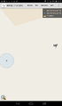
| Sun 17 Apr 2016 in 49,8: 49.3700107, 8.3712059 geohashing.info google osm bing/os kml crox |
Location
A thicket near the community swimming pool in Schifferstadt.
Participants
Plans
Expedition
I wasn't sure if I would have the time to go there, and it was raining all the time in the morning, so I had almost given up. But the rain stopped in the early afternoon and I got ahead with work faster than expected. So I just took my bull, rode the nine kilometers to the hash and had a look. It was 70 m from the road and there was a thicket that I couldn't fight for even 10 meter. So I tried it from the other side. There was a football pitch and a lawn in front of the thicket. Behind the pitch was the fence of the pool.
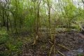
I crossed the lawn and entered the thicket. I jumped over a small ditch and reached another - wider - ditch. I crossed this one to, with the help of a big piece of wood. But on the other side -still 30 m to go - I was stopped by the thicket, that was now mostly bramble. So I decided to turn back. Just when I walked back over the lawn, little lady called me and asked when I'd come back. So I didn't start another attempt and rode back home.
Tracklog
Photos
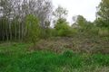
thicket from the road
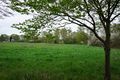
looks much better from the other side
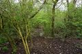
there even seems to be a path in the thicket - with some water running over it
the next brook was to wide to jump over it
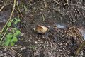
but this piece of wood helped
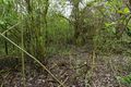
But I could't continue the walk on the other side
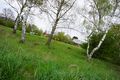
some soccer player nearby
as close as I could come (28m)


