Difference between revisions of "2016-05-01 34 -117"
imported>AeroIllini ([live picture]I left behind a pile of rocks to mark my passage.) |
imported>AeroIllini (→Achievements) |
||
| Line 67: | Line 67: | ||
| date = 2016-04-30 | | date = 2016-04-30 | ||
| name = AeroIllini | | name = AeroIllini | ||
| + | | image = 2016-05-01_34_-117_AeroIllini_1462113741138.jpg | ||
}} | }} | ||
| Line 78: | Line 79: | ||
| date = 2016-05-01 | | date = 2016-05-01 | ||
| name = AeroIllini | | name = AeroIllini | ||
| + | | image = 2016-05-01_34_-116_AeroIllini_1462121910316.jpg | ||
}} | }} | ||
Revision as of 01:21, 2 May 2016
| Sun 1 May 2016 in 34,-117: 34.7565890, -117.1561773 geohashing.info google osm bing/os kml crox |
Location
The point is in the Stoddard Valley Off-Highway Vehicle Recreation Area, beside I-15 between Victorville and Barstow.
Participants
AeroIllini, visiting from Seattle.
Plans
Expedition
AeroIllini arrived at the OHV Rec Area at 7:30 in the morning, the air filled with the ambient sounds of birds singing, trucks downshifting, and the staccato pop-pop-pop of the shooting range across the highway. A short 0.5 mile hike from the parking lot, across several hills, led to the point, which was a small pile of rocks near the bottom of a valley.
AeroIllini spent several moments enjoying the view and snapping a few photos before turning around and returning to the car... off to the next stop on today's Multihash tour! See 2016-05-01 34 -116 for the next stop.
Tracklog
Photos

Success! @34.7566,-117.1562
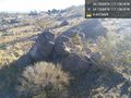
This pile of rocks marks the spot. @34.7566,-117.1562
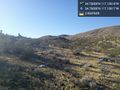
Some of the surrounding countryside. @34.7566,-117.1562
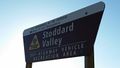
The entrance to the OHV Area.
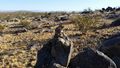
I left behind a pile of rocks to mark my passage.


Achievements
AeroIllini earned the Consecutive geohash achievement
|
AeroIllini earned the Multihash Achievement
|